 Without a doubt, sports is great for anyBODY. It promotes a healthy lifestyle, develops self-esteem in its participants and provides a tremendous outlet for self -expression. David Lim was rendered partially disabled as a result of nerve damage from Guillain-Barre Syndrome, a rare nerve disorder where the immune system attacks the body’s peripheral nerves; sometimes irreparably.
A key goal of ASCENT 8000 is to encourage everyone to see that the disabled are just like other people who need sports in their lives. The major groupings of disability are ( with differing degrees of impairment ) deafness, blindness, cerebral palsy , mental impairments and physical disabilities such as polio or resulting from amputations .
 A disability has a profound effect on the lives of those who have to live with them as well as for those around the disabled person. Recognition of the special needs of the disabled in the Republic of Singapore has not been as great as in most developed countries but support is growing
ASCENT 8000’s key partner in this quest is the Singapore Sports Council for the Disabled whose mission is:
“FOUNDED ON THE BELIEF IN THE DIGNITY,CAPABILITY AND VALUE OF DISABLED PERSONS, OUR MISSION IS TO ENABLE OUR DISABLED SPORTS PERSONS TO REALISE THEIR INDIVIDUAL POTENTIAL BY PROVIDING THE OPPORTUNITY TO PARTICIPATE AND EXCEL IN SPORTS BOTH RECREATIONALLY AND COMPETITIVELY ”
USEFUL WEBSITES
- Singapore Sports Council for the Disabled
- Disability Sport USA
- Disability Sport England
- Amputee Sport Resources Online ( really good site! )
- Directory of Sports Organizations for Athletes with Disabilities
- Guillain-Barre Syndrome Support Group ( UK)
- Guillain-Barre Foundation International


DISABLED MOUNTAINEER KNOCKS OFF HIMALAYAN PEAK IN WARM-UP FOR UNIQUE DOUBLE (Media Release)
On April 2nd, partially disabled Singaporean mountaineer David Lim summitted Mera l Peak* ( 6476m ) as part of his acclimatisation for climbing two of the world’s biggest peaks, Shishapangma and Cho Oyu. The expedition, known as ASCENT 8000 is aimed at increasing awareness of the importance of disability sport.
Mera Peak is located at the head of the quiet and remote Hinku valley, an area of the Mt Everest region rarely frequented by trekkers or visitors. Lim, Singapore’s first professional mountaineer, and his Nepali partner MB Tamang did not have the usual kitchen crew that all teams use in the Hinku. They travelled into Mera basecamp with just two porters.
Climbing in light-weight style, Lim and Tamang placed a high glacier camp at 5,700m on March 31st and then made a summit bid starting at 4:30am on April 2nd. The route on Mera Peak is normally straightforward but consistently bad weather on the 9-day approach meant the team had to struggle through soft snow and -20degree conditions. There were no other teams on the mountain at that time.
Lim says:” There were storm clouds at a distance over the Mt Everest region and to the north, the sky was simply black. But to the west of us there was clear weather and the winds are not so high so we went for it.”
The climb took six hours and the summit reached at 1030am. Lim called Singapore via his ACES satellite telephone from the summit’; “just as clouds came over and a hasty descent was in order”
Lim sustained some minor frostnip in his fingers and a bad pressure bruise on his right, disabled ankle. This necessitated walking out of the rugged Hinku valley for three days wearing a sandal as footwear for his right foot.
“It was pretty tricky, balancing on rocks, icy patches for hours each day with a light boot on one foot and a sandal on the other!”, he said.
Now in Kathmandu, Lim is headed for Tibet on Saturday to begin his climbs of Shishapangma ( 8012m ) and subsequently Cho Oyu ( 8201m ). The expedition’s progress can be followed on http://www.everest.org.sg
” I feel pretty acclimatised of the big event,” said Lim. ” I just need a bit of luck with the weather for the big climbs ahead.”
ARCHIVED REPORTS:
May 27th, 2002
Clarification from Kathmandu:
* Mera Peak comprises three summits; the highest being the North summit at 6476m. MB Tamang seemed certain the peak we were climbing was the ‘ summit’ ( he had climbed there in 1993 ) and one map that we checked showed it to be the highest point. But upon checking other information sources, it now appears that the highest point was NOT reached. We had reached the Central Summit ( 6461m ) , a prominent ‘summit’ on the complex glacier plateau. While most teams consider this the ‘summit’ as the North summit has a large crevasse cutting across the entire route and insurmountable without considerable equipment, we do not consider ourselves as having climbed to the top. Nevertheless, we feel we had done a good job climbing this 6000m subsidiary summit as part of our warmup climb for the 8000ers.
David Lim
2 Apr 2002, 10:35am
Mera Peak
Hi there!
Calling from the summit of Mera Peak. Standing in the middle of a fantastic white-out right now. The whole peak is in the midst of heavy cloud cover. We can’t take any photos or video, so MB and myself is spending our time eating and drinking!! Cheers!!
The climb up was difficult (even though this was just an acclimatisation climb), we had knee deep snow and mush. Had a head cold and this was affecting my breathing but I just kept at it… sucking air and putting one foot in front of the other.
Right now, after a bit of food and water, I feel much better, already… hey!!! Looks like the sun’s coming up…
We will be moving down to Lukla over the next four days. See ya!
1 Apr 2002, 5,600m
Mera High Camp
Reached Mera High Camp yesterday. Will make a summit attempt tomorrow, early in the morning. The weather have been bad, with lots of mushy snow in the afternoon. We have been getting “graupel”, snow that comes in the form of small lumps. This is not the usual snow flakes. This makes the going a bit harder. We had to plough through the mush. From where we stand, we can see the north side of Mt Everest. The weather does not look too good over there too. Batteries running a bit low…
30 Mar 2002, 12 noon (Singapore), 5,415m
Mera La
Reached Mera La (5,415m) – (Mera Base Camp) yesterday. We will go for Mera High Camp on Sunday. A long walk from Khare. We have been having snow showers in the afternoon.
We are having blue skies right now, and from where we stand, we can see Mera Peak standing up there in the clear blue sky. The air is dry, expected, and MB and myself have been drinking loads of water, tea and stuff to keep hydrated.
We are in good health and MB is trying his hand with the video camera. Looks like the clouds are coming in and we might be having a bit of snow later.
27 Mar 2002, 4200m, Thangnak
Had a hard day plodding yesterday. Walked from 4,100m down to 3,400m to Kothe. The walk involves a lot of up and downs. Old paths were swept away recently because part of Sabai Tsho, a mountain range, broke away in an avalanche.
Have reached Thangnak, a little hamlet, today. This village is at 4,200m. The weather seems to be getting better, a lot more sunshine in the morning. We met an Australian team of 4 persons, returning from their climb. They look pretty happy with themselves.
We have been having meals from the small guest-houses enroute. We get a lot of carbohydrates like rice, potatoes and dal-baht (a thick Nepalese vegetable stew), and the occasional egg. Somehow I feel like sinking my teeth into some meat… (we are saving our dried meat for later). Tomorrow, we will move on to Khare before we reach the base of Mera, our first challenge.
Both MB and myself are feeling great, spirits are high even if we are feeling a bit hungry for something on hoofs.
25 Mar 2002 (4,100m, Hinku Valley)
Arrived at Lukla 2,500m on the Mar 22. We were delayed by bad weather and as a result lost 3 hours. This means that we only begin our trek on Mar 23. We established our first camp at 3,400m. Had lots of hot tea and rice, burp!!
Mar 24, we trekked further and reached an altitude of 3,800m. Nice hike. We had showers of “snow” in the afternoon and evening. Mar 25, we went up to 4,000m. Today, we crossed 2 passes one at 4,500m and the other at about 4,700m at Zatrewa La. Met the Shishapangma Expedition members, Mok, Robert and Edwin coming down from their acclimatisation climb. They are well and healthy. The last time the four of us were together was on our 1st Mt. Everest Expedition. It’s been a while…
After the climbing the passes at Zatrewa la, me and MB Tamang descended down to 4,100m into the Hinku Valley. Tomorrow, we will make our way to Tadna, if the weather holds up. Right now, it is cloudy with occassional sunshine. We had a bit of”graupel” today. Graupel is not something we eat. It is small round balls of snow!!
I have a bit of sinus today but that aside, I feel good.
23 Mar 2002
(4:12pm Satphone Report at 4,300m.)
Hi, This is David calling.
We were delayed by some bad weather yesterday, so we could not get on an immediate start from Lukla, the mountain airstrip. But we have finished the day’s trekking today at 4:15 pm (Singapore time). Tomorrow I am deciding whether we will go for the passes at Zatrewa la at 4500m and 4700m or spend another night here at 3400m.
Interesting thing is that I may get to meet Mok and boys from the Shishapangma Expedition as they are also acclimatising in this area. Feeling good, everyone in good health.
21 Mar 2002
Greetings from a very wet and soggy Kathmandu. For the first time in seven visits, the mountains were not visible from the Thai Airways flight, so even the excellent Thai dessert served on board could not make up for it. At 4:30pm the heavens opened up. Apparently, the recent unseasonal rainy weather is like a barometer of people’s feelings -in Thamel at least. Here, in the heart of the tourist district, a gloomy mood prevails. Business is down and it’s palpable. The shopkeepers are more eager for business and the streets less crowded.
I will take the mountain flight into Lukla tomorrow for the start of a 3-week acclimatisation climb. All the rain down here means snow up high, so I’ll take it as it comes. There will be limited pictures posted from now but I’ll continue to send dispatches by audio….and update picture files when I get back in April.
Dave
Mar 17


Top: Mayor Heng ( left ) trying on an 8000m down suit as David lends a hand. Above: David’s ACES satellite telephone and Canon digital cameras
ASCENT 8000 had its pre-departure media event on Mar 14; attended by 25 members of the media, supporters and Expedition Patron, Mr Heng Chee How, Mayor of Central Singapore Council.
Said expedition patron and Central Singapore mayor Heng Chee How:
‘David is a shining example for Singaporeans on how we can set our goals and overcome and exceed our perceived limitations with determination and belief.’
The story was captured in the press in The Straits Times, Lianhe Zaabao and Today newspapers and also on Channels 5, U, I as well as the regional Channelnewsasia network.
David departs on Mar 21st
Feb 11
Note from David . Weekly training is being cranked up with at least two three/four hour hill sessions with the usual 15kg pack plus additional cardio sessions. Core stability exercises also figure in my training, especially since his legs dont work like normal ones. The often neglected back and waist muscles are critical in maintaining stability when carrying large loads. Weight sessions in th egym have been scaled back but work is ongoing for strength maintenance.
Weather: After a wet January, hot and dry conditions are back but this is all relative since humidity here is usually 90% which makes any prolonged workout rather dehydrating. The trick is to keep drinking….
Mar 13
One week to go! ASCENT 8000 is pleased to receive on behalf of the Singapore Sports Council for the Disabled a cheque for $1,000 from NTUC Income Cooperative, a household name in insurance and essential services here.
![]()

The Cho Oyu Route:

The long route up Cho Oyu. Photo taken from Advance BaseCamp.

Reaching Camp 2 after climbing up 2 ice cliffs, the route upwards remains tough and challenging.
ARCHIVED REPORTS:
June 13
After numerous misleading press and media reports, primarily by the local newspaper, The Straits Times, pressure from the climbing community as well as a sense of doing the right thing has made me issue the following statement. The Singapore team in question have now admitted, after other media covered this controversy, that they did not reach the top of Xixabangma as previously declared in the media. However, they have not accepted that their claimed alpine-style ascent is in dispute. The reader/surfer can read the following, surf to the relevantwebsites and decide for themselves. The Straits Times have elected not to publish the letter below to correct their previous reports nor report on the controversy.
ISSUES OF STYLE AND ETHICS IN MOUNTAINEERING:
TEAM DID NOT CLIMB TO THE TOP, AS CLAIMED
The Singapore Xixabangma team and my former Everest 98 team-mates returned recently to accolades for their fine efforts on the mountain It was an all-Singapore summit day, without the use of oxygen, and on one of the world’s highest peaks.
But the Singapore team did not climb to the top of this mountain, as reported in the media. They were inaccurately described as having climbed to the top of the peak when the true ( Main ) summit is several hundred metres away at the end of an exposed ridge and higher than the Central summit which they climbed instead.
The team’s claim to have climbed it alpine-style is also questionable.
Alpine-style climbing evolved in the Alps and is broadly defined as climbing a route in a single, continuous push without the use of external help eg sherpa porters to carry gear, without the use of pre-placed fixed rope, camps, caches of supplies and without reconnoitring the route..
Their basecamp manager’s clarification that the public had been told that the climbing sherpas would be hired for only the acclimatisation/ build-up phase and not the summit climb misses the point entirely.
If sherpas are used to lessen the team’s fatigue immensely by pre-placing camps, carrying loads and so on for weeks prior to an “unassisted” summit push by an all-Singaporean team in the final days of the expedition, isn’t this amounting to external help ? More importantly, by reconnoitring most of the route before the summit push, the team sought to remove as much of the unknown factors of the route which are part of alpine-style climbing.
Sir Chris Bonington, the leading British expedition leader of his generation, when asked, thinks that the Singapore ascent is not in alpine-style. He said,” true Alpine style is without any kind of preparation or recce’s” .
The others who doubt the team’s claim include Ms Elizabeth Hawley, the eminent Himalayan mountaineering historian and Mr Joss Lynam, Head of the Expeditions Committee of the Union of International Alpine Associations ( UIAA ).
The team placed on themselves a significant climbing standard but then sought to tweak the ‘rules’, the essence and spirit of alpine style climbing until it became an issue to anyone with a strong background and understanding of this noble ideal and style of climbing. This is not a trivial issue for mountaineers here and abroad.
In the team’s website ( http://www.xixa.com.sg/team/team.asp )
, a member of the team also claims the first Southeast-Asian alpine-style ascent of a 7000m peak in 1996. In reality he had previously recce’d most of the route on acclimatisation climbs and had used a sherpa to help carry a load and climb with him on his final summit push.
It seems the definition of “alpine style” that excludes use of such external help is modified by members of the team when it suits them. Surely this cannot be right.
This in itself does not detract, as mentioned earlier, from what would be described as a fine lightweight ascent of the lower summit by the team which does them credit. But it would do them more credit if they had refuted the misleading media reports of their climbing to the top as well as conceding their claim to have climbed the peak in ” alpine style”.
David Lim
26 May 2002, Kathmandu
60 Days on High Ground
I arrived back in Kathmandu on Friday evening, our driver expertly throwing our Land Rover Defender Mk 2 around rain soaked roads from Kodari. Dodging villagers, dogs, other vehicles, all went well until at extremely low speed in a Kathmandu alley, he ran into a low metal grating. You can’t win ’em all.
At this stage, I’d like to thank all my supporters, sponsors and well wishers. Amongst the sponsors, I’d like to thank the people from CAMP Scandinavia, the only foreign sponsor (not even an office in Singapore) for their assistance and belief in me. Their new prototype ankle-foot brace has done the rounds here. Canon, who kindly arranged for a mission-critical cable to be supplied in Kathmandu when I was missing it last month. I have some neat footage but missed some wonderful chances 2 days ago. We were desperately clinging on for safety that such chances had to be let go.
The Singapore Sports Council for the Disabled have been a solid but quiet partner as have the Singapore Sports Council. Asia Cellular Satellite have worked wonderfully, and allowed me to send the exciting photos and dispatched consistently in these 60 days as well as helping out when a tragedy needed some SATCOM use up high recently. Thanks too to Ting Sern who had put together the SATCOM power solutions.
I can tell you how distressing and lonely it was at 7,900m on Cho Oyu when I had to beckon to MB Tamang to descend from his position slightly higher up and call off the summit climb. There were not only tears for the disappointment but also tears of exhaustion. 60 days of climbing not one, two but three peaks and no success on the 2 main objectives. In short , I had given 100%,maybe more, but was beaten – first of exhaustion and insufficient fixed line on Shishapangma and then of pure exhaustion from the sustained difficult ground on Cho Oyu. My bad leg had let me down. A summitter with experience with GPS coordinates has now corrected all my previous altitude markers ( from my uncalibrated wrist altimeter ). These are:
Camp 1 = 6,350m
Camp 2 = 7,100m
Turnaround point = 7,900m
Now with several days of rest I have looked back at the most intense climbing expedition of my life and have taken stock. In my mind, when no disabled climber in the world has attempted such two peaks back-to-back and when many are climbing with a whole posse of sherpas for support to my sole Tamang partner, the odds were stacked hugely against us. Encouragement comes from strange quarters. Climbing sherpas throughout this trip have made great remarks about how wonderful it is that I’m trying to give these peaks a shot without the usual entourage of foreign guides and local support teams. To have praise from these enormously cheerful and strong climbers makes me feel proud to keep the flag flying Italians, Dutch, Germans have also given me much support even if I am I’m climbing with such difficulties.
To have climbed to 7,600m (Shishapangma) and 7,900m (Cho Oyu) over tough terrain with no external aids save what fixed line was available was an uncompromising position to take. Perhaps in the future I might accept more help. We had no air or ground support to call upon if the going got tough or if we lost equipment and I think this style of climbing makes easy successes impossible. But we leave with our self-respect.
Dave
26 May - Death On Cho Oyu
Tragedy Strikes the Irish Team.
Three Irishmen from both the Republic and the north came to climb Cho Oyu. My only contact with them comes at Camp 1 when I meet them coming down from Camp 3 after a successful summit bid. The following account is not necessarily the most accurate but tries to capture the gist of what happened on those fateful days. The full story no doubt will emerge from the survivors of the climb.
In the second week of May, Richard and Humphrey had planned to summit from Camp 2 at 6,925m, normally a practice reserved for only the strongest climbers (or sherpas). Adam elected to climb to Camp 3 and meet with the two others in the early hours of the morning. Richard and Humphrey left very early, hooked up with adam and proceeded for the top. However, very shortly after leaving Camp 3, Adam was not feeling the best and decided to descend to Camp 3/2. He was advised to rest up and keep warm and await for the returning climbers. He had a radio.
The two Irishmen summitted and descended late in the day to C3 and then the following day to C1 where I met them. The following day, their elation was tempered with the fact that they had had no radio contact with Adam (there was a radio at their camp at ABC). Evidence at C2 showed he was there briefly but no other signs. The real sense of desperation and fear sank in when they contacted Jamie McGuinness, a mountain guide with whom they had some rapport. Jamie reported no sign of Adam’s rucksack or him at ABC.
If someone is missing for 2 days on a big hill like Cho Oyu and is nowhere safe on the mountain, there is a 99% chance he is toast. Still, the two exhausted climbers went back up to the first icecliff where a large crevasse may have swallowed Adam up. The two descended to ABC, lacking time, energy and resources for a full SAR. My ACeS phone came in handy for them to report their missing friend to the UK insurance underwriters. They also hoped to contact the family of Adam.
A day later at Camp 2, a sherpa reported seeing a body in a specific crevasse. It looked new, and had a jacket which matched Adam’s. The mystery seemed to be over although the tragedy had only just begun. There are two fixed ropes passing this section. A pink one passes cleanly by the crevasse. The other ends abruptly just above the lip of the crevasse. It is not inconceivable that Adam had clipped into this rope and then found it ending abruptly above the chasm. Unclipping, he might have slipped and taken a quick plunge into the crevasse. We don’t know.
Jamie, with whom I share kitchen facilities at Cho Oyu ABC, requested I poke my head over that crevasse and take a few photos of the body for insurance and death certificate purposes. This was a grisly task but one which I accepted as part of being on such an expedition – one tries to do what one can to help others if one can.
In the end, Adam’s parents requested a full body retrieval and one is currently under way, interrupted temporarily by the bad weather last week. McGuninness and Tshering Bhote are attempting the retrieval.
The friends and parents of Adam receive my full sympathy and condolences and I hope the retrieval and repatriation of the body and/or personal effects will help everyone achieve some form of closure of this tragic event. Cho Oyu is considered one of the ‘ safer’ 8000m peaks. However, Adam’s death and the death of three sherpa climbers in 2001 is a reflection of how these mountains have a dozen places where you can get yourself killed.
Dave
23 May 2002 Chinese BaseCamp (4,900m)
(22:20hrs Singapore)
It was a long walk down to BaseCamp with the yaks. The yaks are wonderful creatures, able to carry a good size load. But walking behind yaks is another experience. One always have to keep an eye on where I put my foot down.
Next leg of my journey will be to return to Kathmandu and that long awaited bath.
Dave
20 May 2002 Advance BaseCamp
Two fried eggs, a pancake and a sprinkling of black pepper. If you’ve just had a horrible 9 hour day descending in a windstorm, this is the closest you’ll get to culinary heaven. I missed adding that apart from 2 -3 mugs of hot tea, you’ve also had nothing to eat but six small biscuits all day. (see route!!)
ASCENT AND AN EPIC DESCENT
I’m down from Cho Oyu. We didn’t make the top but got to 7,800m and past most of the technical difficulties of the route. We got to ABC on May 13th, rested a day and went straight up to Camp 1 (6,300m) or so. This camp is right on the glacier’s edge. This was followed by a hard haul over 2 ice cliffs and then to Camp 2 (6,925m). In 1997, I recalll we had a fine day to Camp 3 at 7,350m and took (for me anyway) 5 1/2 hours. This time, in bad (snowy, cloudy) weather, we made it in 3 1/2 hours and with bigger loads – you go figure….
The weather was brilliant on Friday and we thought we’d missed the best of it. Our day on Sunday started on 4am where we climbed up to the 50m vertical rock band. Unlike the 1997 route I was successful on, the fixed line and route took the most direct and thus most vertical approach to the summit block. The route was about 50 m through granite and then 50 degree snow couloirs for about 100m and the an unprotected slabby bit that went on for another 100m before the big snowpatch underneath the summit block.
By this time, it had taken me about 5-6 hours and the wind was picking up. It would be easy to say that this was why we turned round. But the truth of the matter is that the very tough terrain was murder on my bad leg and the energy spent compensating for it had completely fatigued me. We had taken on the mountains on its terms and we’d been beaten. We had been leading the small pack all the day and were happy to let an Italian couple at that stage take over and make the top. I’ll send a pic of the route soon. I had given 100% but it wasn’t enough. We dropped back to Camp 2 – disappointed but knowing we had done our best.
If there was one reason for failure to summit both Shishapangma and Cho Oyu it would be a lack of compromise in style. Perhaps in the future, I should, like so many disabled climbers gunning for the big peaks, get a posse of sherpas to lay fixed rope ahead of me and / or carry everything. My insisting on doing as much as I could, this may have lessened the margins of success. I’m not sure where the line between a mountain tourist and adventurer lies but I’m sure I’m well inside the right line.
The descent the next day was a small epic. Windy weather had been predicted but not the 70kmh sort that knocks you of your feet. My camping mat went ballistic as a gust of wind caught it. It’s in the next glacier system now. Descending the two ice cliffs was also scary and tough. My left hand was half frozen and the ropoes were stuck in the ice. Finally, we cleared these obstacles only to meet more strong winds. The same Italian couple were almost blown off the ridge. Finally, the four of us roped ourselves as two pairs and inched our way down – four legs per group better for balance in the strong winds.
It was 8 – 9 hours before I was back in ABC – and now for those eggs and pancakes by Gyanu, our cook.
Dave
20 May, 2002 Advance BaseCamp 5,600m
(23:05hrs Singapore)
We started the day with the hope that it will be a quiet climb down after our summit attempt. We were exhausted from yesterday’s attempt. Moving off from Camp 2, we started towards the ice cliffs. We had to get down. As we approach the cliffs, we began to get a bit of a breeze. Strong and gusty.
When we reached the ice cliffs, we found that the ropes were glued down. The freezing cold has effectively glued our ropes to the walls. Getting down seems a real challenge. MB and me spent at least 15 mins trying to figure out how to get down. The winds began to pick up. Exposed on top of the ice cliffs, we decided to make our way down. MB and me roped together and wormed our way down. We were like flies on a wall. Using what rope we can find, rope that stayed detached from the wall., we struggled down. Being linked to MB has been very comforting. MB is a pillar of strength. Midway, as we crabbed down the ice walls, the winds started to pull and tug at us. I think they were blasting at about 70 miles/hr. It is like being grabbed and pulled from behind. Only in this case, when I looked over my shoulder, I see the white snow flying in the winds. A mistake here will mean falling down the ice cliffs. Clinging on the ice wall, I feel that if I were to let go, I could actually fly off in a wind like this. As if to answer to my thoughts, one of my karrimats ripped off from its harness on my backpack. It flew off in the direction of Mt Everest… perhaps if any climber finds a karrimat that has my name on it flapping about, please return it to me. I would appreciate it very much. That mat and me have gone a long way together.
After the first cliff, we had to get over to the next cliff. We crawled… crouching down often when the winds get too strong. At this stage, the winds sounds like a huge jet engine, howling, whining and screaming. Here we pause for a moment as we caught a glimpse of Adam’s body, he lay in a crevasse near these cliffs. We said goodbye to our friend and continued. I understand that 2 climbers are still up at this altitude trying to bring Adam’s body down. It will be difficult. We reached Camp 1 after 3 to 4 hours of climbing. It was a climb of an epic proportions.
From Camp 1, we dragged ourselves down to Advance BaseCamp, reaching it at about 6pm our time. We have been on our feet for almost 10 hours. In this journey, I had only a few biscuits and water. Reaching ABC, we stopped at the kitchen tent and rested. Drinking warm water and tea. Looking back up to Cho Oyu, MB said, “Tough route.” We climbed on the mountain’s terms, giving 100% of our energy and efforts. It has challenged us to the core.
Amazingly, both MB and me are healthy. Have a bit of a dry cough right now. My fingers were nipped during the climb down the cliffs. Feeling is returning to all my digits now. Resting now, time for a bit more tea…
Dave
19 May, 2002 Camp 3 (7,350m)
(16:16hrs Singapore)
Have just returned to Camp 3 from our summit attempt. It has been a tough, tough day. We reached 7,800m at the Summit Rock before turning around, about 400 vertical meters away from the summit.
We started climbing at 4am this morning. We had to break trail as there were no one in front of us. Quiet on the mountain. Probably because winds are expected to pick up tomorrow to levels between 40 to 75 knots, very strong gale force winds, very dangerous to be on the mountain. The going was not easy. Winds picked up as we begin climbing. We began with a snow covered slope. This lead us to a vertical ice cliff of about 50m high. It was very difficult climbing up this wall. And getting over this cliff took a considerable amount of energy. It was exhausting. Once over, we continued climbing up a snow covered slope. The slope has an inclination of about 50 degrees. At this altitude, I had to rest and suck air every 6 to 10 steps, the thin cold air burns. After the exertion at the cliff, my legs felt like lead. The slope continues and we started to encounter a lot of broken snow. This is soft snow sitting on top of loose rock. Very wobbly and difficult for me with my bad ankle. After quite a while of this, the snow thickens. Then it was soft snow until the Summit Rock at 7,800m. It took us 5 hours to get to this spot. To continue to the summit would take another few more hours, leaving us with no time to turn around safely. We decided then to give the summit a miss. We have pushed to our max, but Cho Oyu has eluded us.
This route to the summit is much tougher than the one I took in 1997. The cliff beyond Camp 3 took a lot of energy to climb. It has exhausted me. One consolation is that I have surpassed my personal limits again in this climb, going up to 7,800m without bottled oxygen.
Resting for a short while here at Camp 3 before going down to Camp 2 for the night. I feel very, very drained. Tired. Thirsty, very dehydrated. We are boiling water before moving on to Camp 2. The 2 months of unrelenting effort has also taken quite a bit out of me. Feeling really mortal… our main job now is to get off the mountain safely. Winds are picking up…
Dave
18 May, 2002 Camp 2 (6,925m)
(12:35hrs Singapore)
Woke up this morning to a white-out on Cho Oyu. Strong gusty winds and loads of snow greeted me and the other climbers in Camp 2. This is the kind of weather that makes you want to dig a cave and hibernate until the sun comes up again. Stuck my head outside the tent just a few moments ago, can’t see very far. At most, 100m. A white-out on the mountain can be very dangerous, a climber can walk off a cliff or into a wall of ice, or worse, step on a much larger climber with your crampon-ed boot.
Climbers are sitting in their tents waiting for better weather conditions. It doesn’t look good. Any attempt up to Camp 3 would be difficult and arduous.
Camp 3 (7,350m)
(18:20hrs Singapore)
Guess what… I’m at Camp 3!!!
MB and me decided to make an attempt this morning. Got bored sitting around in our tent. We started climbing at 11:30hrs our time. Conditions were not good. Thick soft snow (the kind that you can make snow angels with). We had to break trail up to Camp 3. Breaking trail means that there is no trodden path for us to follow. The wind and the snow has wiped everything out. It feels like we were climbing an untouched mountain. As we moved off, the weather remains “crappy”, we were blasted often by wind and snow.
The route we took today was different from the one I climbed in 1997, this route is more direct, passing some pretty deep crevasses and steep climbs. The amazing thing was that in 1997, I took 5hrs 30mins to get to Camp 3, and in good weather… blue skies and sunshine. Today, it took us 3hrs and 30mins in bad weather and me with a bad ankle. Hmmm, maybe its the “crappy” weather or bad ankle.
We will make a summit attempt tomorrow, at dawn. The weather is not with us, it is likely to remain “crappy” and mushy. It will be a difficult climb.
Dave
17 May, 2002 Camp 2 (6,925m)
(17:50hrs Singapore)
Reached Camp 2 after 5 hrs 30 mins of hard climbing. We are sharing facilities of another expedition here… they have been summitting over the last few days, and they have left a bag of extra food for us!! MB is going through it… hee hee hee, it’s like Christmas. Only problem is that these items are labeled in Japanese. Guess we just gotta try it out and hope that we don’t end up eating wasabi.
The climb up the 2 ice cliffs was very tough. With the changing weather conditions and temperatures fluctuating, the ice looked more cracked than usual. Climbing an ice cliff is difficult, I have to wear crampons (those spiky things that we attached to the bottom of our boots). If there are no toe-holds (little steps for the toes) I have to kick into the cliff and dig in. With my weak ankle, it is quite a strain climbing. One particularly difficult section, where I had to haul myself over a ledge by pulling on a fixed rope attached to an ice screw… I discovered after climbing that section, the screw has loosen and has worked out halfway from my tugging. It is not fun to fall from an ice cliff up here!! Anyway, I just screwed the screw back in again and moved on. One have to just focus on the job and carry on.
My ankles are aching from the workout today. Other than that, both MB and myself are healthy but hungry, thirsty and tired. One of Jamie’s (the leader of the expedition whom we are sharing facilities with) sherpas helped us out today with carrying about 10kg of our gear. This means that MB and me had a slightly lighter load today. I carried about 10 kg on my back. It is still very hard, the weight seems to grow heavier every step I take.
I can see clouds building up in the horizon. It might snow tonight but the sun’s shinning right now. From here we can see the route to Camp 3. It will be a grunt tomorrow but at least there are no ice cliffs. Water is boiling, tea…
Dave
16 May, 2002 Camp 1, 6,300m
(16:10hrs Singapore)
Woke up this morning and decided to take a break. The view here is just too good to waste, fresh air and the quiet sounds of the mountain. Resting in Camp 1 for the day before I make that excruciating climb up those 2 ice walls before reaching Camp 2. This means that MB and me will make a summit attempt on Sunday instead of Saturday.
Camp 1 sits on the edge of a glacier, literally on the edge. There are about a dozen tents, some on ice and the others pitched on scree (loose rocks and pebbles… the kind that can creep into your boots and gives you pain).
One of the tough part about climbing mountains is that after a certain altitude, your mouth cease to taste food well. Everything that I shovel into my mouth starts to taste the same. Oatmeal tastes the same as porridge. Only the really tasty wakes my tastebuds up, fried salted fish and other gamey stuff. I can only dream on… For dinner, I guess that I will tuck into a simple meal of instant noodles boiled with some bits of dried chicken.
Today, has been rather eventful. Spoke to climbers going up and down. The news is that a climber, a friend, has gone missing since yesterday. He was returning from a summit attempt. There was evidence that he was at Camp 2 but there was no sign of him in Camp 1 or even in Advance BaseCamp. Climbers searching the area have found no signs. We are all very concerned. We can only hope as the search continues while there is still light. Dave.
15 May, 2002 Camp 1 (6,300m)
Reached Camp 1 after 6 hours of climbing, walked through a lot of scree slopes and ice. The skies were blue today. Felt good but exhausted. The last time I climbed to this spot, in 1997, I did it with no load. Today, I carried slightly over 15kg of equipment and food. MB is remarkable, he took a load of about 30kg. We are both very tired right now.
Getting a bit of clouds right now. We have been getting bits of snow now and then through the day. Camp 1 sits exposed on a broad ridge. Camp 1 gets a bit of a breeze sometimes. From here to Camp 2, we will follow the ridge. We will have to climb 2 ice cliffs, this is going to be tough, before reaching Camp 3 tomorrow.
Boiling water now.
14 May 2002 Advance BaseCamp
(17:20hrs Singapore)
Pre-summit dispatch
We’re taking a gamble tomorrow by heading for the summit. We have weather predictions showing low winds at the 9,000m mark for the 18th. The schedule will take up up the 5 hour moraine slog to Camp 1 (6,400m) and then over 2 steep ice cliffs to Camp 2 (6,800m). A sustained 45 degree snow slope goes to Camp 3 from whence we will give the top a shot on the 18th May. The summit block is looking pretty formidable with much rock showing through snow.
Radio reports from today’s summit teams at 7,800m this morning had one describe the route a a ‘real bitch’. It’s steep and tough. Weather has been a mix of clouds, swirling snow showers but no strong winds. This seems to be the outlook for the week.
We can continue to stay here for 3-4 days more, hook up with some Dutch and Germans or strike it out while we have this stable sort of weather. This means going it alone for the top. It’ll be exciting with an extremely uncertain outcome
In the midst of all this, please spare a thought for one of the big reasons for ASCENT 8000 – to demonstrate that the disabled are not always unable. 5,000 Singaporeans are wheelchair-bound and thousands more suffering from one or more disabilities. Sports helps to get them out and about. Do spare a minute and go to the links I have to the Sports Council or the Disabled. Volunteer your time, contribute!
Disability sports is usually not a popular issue with the major media who, in Singapore, prefer to focus on exaggerated near-death encounters with crevasses on mountains or bak kwa (honey roasted pork) munching heroes.
It’s hailing graupel and I must be off. Thanks for all the kind emails (hola! Gil) and well wishes.
Audio dispatches only from tomorrow
Dave
May 13, 2002 (Monday)
Advanced BaseCamp, 5,600m (16:20hrs Singapore)
Reached camp this morning. It was a great 4 hour walk. The skies are blue, the sun is out… everyone is in a cheerful mood. This is the weather for walking in the Tibetian highlands. Woke up this morning, in Intermediate Camp, and was rewarded by a great view of Cho Oyu. The day started off with blue skies and Cho Oyu looked just spectacular, so beautiful that I almost forgot to breath.
ABC has a bit more creature comforts than Intermediate Camp. Have a better tent (double layered) and the cook tent is a bit larger, one of those orange globe things. All this is because I got to share facilities with one of the expeditions here. Basically, this means that I get to use some of their facilities, while climbing the mountain will be entirely our own effort.
ABC lies in a valley and just south of us stands a 6,000m peak. My tent here sits next to a 45 deg slope that rises to about 1,000m high. Sitting in front of my tent, I spotted a small hare (I think) and lots of tiny ground mice. Plenty of small wild animals. It will be a good idea to keep food well packed. I intend to rest tomorrow before setting up to the higher camps on Wednesday. This will give me some time to do some chores, like washing my socks… and other fragrant items. For the rest of today, I’ll rest, drink tea and eat.
Dave signing off
13 May 2002 Advanced BaseCamp
(20:00hrs Singapore)
It’s sunny here at Cho Oyu ABC. We arrived after a 4 hour hike today and I’m preparing or the summit push on Cho Oyu. It’s taken us 2 nice days of walking to get here and part of me wonders if I’ve missed a good summit window – looking at all the climbers heading up to Camp 3 at 7,400m today.
In any case, I have 11 days here and only need 5 days to make the summit and back. ABC Cho Oyu in is in a moraine valley so getting emails in and out is tough because of the interference with the transmissions caused by the mountains being so close by . But bear with us – some new pictures coming soon I hope!
For my friends at EduQuest involved in the schools programmes, some interesting altitude matters include how water boils at a lower temperature up high so at 7000m+, you can spill boiling water on your hands and not get scalded!.
Another key thing to note is the all -important weather. Every year around this time, the approaching warm monsoon air comes up from the south and west and pushes the unwelcome jet-stream winds ( these go up to 150km/h and stay in the 7000-10000m range ) to the north. So before the onset of the wet and warm monsoon storms on the mountains, there is often a window of opportunity to summit. I’m waiting for it!
Tomorrow is a rest day.
12 May, 2002 Intermediate Camp
5,350m
Reached Intermediate Camp today. Took me 5hrs 30mins to get here, I was a bit faster then when I first came here 5 years ago… Acclimatisation helps. It was a beautiful day today. Bright blue skies, breathing fresh air. Tomorrow, it will be a shorter trek up to Advanced BaseCamp.
Enroute, I met climbers who have just summitted Cho Oyu. It is encouraging to meet them. I hope for the best on our attempt.
The Intermediate Camp is now situated some distance from the “original” one. The older campsite has became filthy and dirty. A by-product of the abuse heaped on it by the many expeditions that comes this way over the years. Sad.
Both MB and me are in good health, except for my dry cough. I feel a bit tired and worn, guessed that this is what long expeditions can do to a person. On an encouraging note, MB related to me a conversation he had with some sherpas from the other teams. The conversation goes like this…
Sherpa : “eh.. what is your climber carrying?”
MB : “er, the usual. Sleeping bag, boots, crampons, snow shovel, water, food…, maybe 10 to 15 kg.”
Sherpa : “Waa… your climber with bad leg is very strong. He carries more. Our climbers are normal. But we carry everything…”
11 May, 2002 Chinese BaseCamp, Cho Oyu, , 4,900m
Hola
It has been a quiet day today. Did managed to get some rest and some hot food. I had Pringles potato chips!! The entire tube. Burp!
Have spent time checking on our gear. They have suffered quite a bit of abuse on Shishapangma. Doing some basic repairs and patching. The weather seems to be easing for the next few days. This will allow me to get up to the higher parts of Cho Oyu with less wind blasting into my face. The snowfall and storms in this area over the last 3 weeks have also resulted in loads of snow on the mountain. The going may be a bit tough at the higher levels. I hear of quite a few camps suffering damage from the storms. I will move off to Intermediate Camp tomorrow.
Water boiling, time for tea!!
10 May, 2002 Chinese BaseCamp, Cho Oyu, 4,900m
Hi there!!
Made it over to the BaseCamp today. Had lunch in Tengri but I didn’t stop for that much awaited bath and rest. Reason being that by getting here a day earlier, I get to prepare for Cho Oyu and also to check out local weather conditions. Besides, I somehow gotten a bit fond of how I look. Took 4 weeks of wear to get this seasoned!!
The Chinese BaseCamp in Cho Oyu remains much as I remembered it since my last climb about 5 years ago. One major difference is the loss of that beautiful green meadow here, what remains is just dust and yak dung. There is also a certain aroma in the air…(and it ain’t me!). Our yaks came in today. They will help us carry our gear up to Advance BaseCamp. The clanging sounds of the yak bells are going on all the time. Kinda of musical.
The meal in Tengri and the warmed air at lower altitudes have helped eased my dry cough which has developed over the last few days. Other than this, MB and myself are healthy and happy. I have stocked up our larder a bit with some large chunks of frozen pork. This will supplement our diet on Cho Oyu. One gets hungry for meat sometimes.
Basically I plan to move off to Intermediate Camp on Sunday, a 6 hour trek. Then on Monday, I will plod on to Advance BaseCamp. This will be a grunt, 6 to 7 hours of trekking. Tomorrow, Saturday (May 11) I plan to rest, do a bit of cleaning and charge up my batteries. Maybe I’ll have that tube of Pringles tomorrow…
ARCHIVED REPORTS:

9 May, 2002 Chinese BaseCamp Shishipangma
Reached camp after 7 hours of trekking. I was greeted by the 2 Tibetian mastiffs, they have grown!! Almost a third larger after two weeks. I guess they were feeding off the left-overs from the meals served to mountaineers.
Most on our gear came out on yaks. I carried just about 10 kilos of warm clothing and gear. It was a good walk, the terrain goes up and down. It was not all downhill. My ankle is OK, and I didn’t have any trouble in the long walk. Started to get a dry cough because of the dust and dry air. Just have to drink more water. Other than that, MB and me are in good health.
The storms on Shisha have wrecked two tents. This will mean that I will have to keep snug into a much smaller and colder single layer tent (double layer tents for high altitudes helps keep the body heat in). Not very comfortable.
I look forward to tomorrow’s truck ride to Tingri. In Tingri, I can get some simple Chinese style food and what’s more important, my long awaited wash. I have not had a bath since 12 April 2002. I guessed I am a bit on the ripe side now. There is a hot spring in Tingri and I look forward to a good soak and thaw out. It would be good to have a look at my face and other body parts… after weeks of everything covered by a grimy mix of sun block, sweat, bits of food and dust.
From Tingri, I will move on to Cho Oyu. We do not have very much room for bad weather on Cho Oyu. The schedule is tight. Once we get to Cho Oyu, it will be a push to get to the higher camps and prepare for a summit push. We hope that the weather and the mountain will offer us a respite and that opportunity for a good climb.
07 May 2002
MEDIA RELEASE FROM ASCENT 8000:
DISABLED MOUNTAINEER RETURNS FROM ABORTIVE SUMMIT BID
Singapore’s first professional mountaineer returned safely to Advance Base Camp at Shishapangma, Tibet without the 8027m summit.
The 6-day summit bid was organised after a spate of extremely unseasoned bad weather and aimed at reaching the top of Tibet’s highest peak on May 6th. The long summit push was preceded by very heavy load carries by Lim and M.B Tamang, his climbing partner.
Three successively higher camps were placed, the last at 7,350m before the summit bid began at 330am May 6th. Weather forecasts had put wind conditions to be moderate. However, after about 200-300 metres of upward progress, sustained stretches of hard ice made further progress too dangerous. While the sections themselves would already been exposed and tricky for an able-bodied alpinist, Lim’s disabled right leg made progress extremely strenuous. With only a shorter length of rope to protect each other over small, steep sections, it would have been too risky and time-consuming to belay each other in turn over the long section of wind-polished ice. Lim turned back at around 7600m.
At the same time the only other summit team, a European team, turned back after one of their members sustained a 200-metre fall higher up. Heavy, localised snowing put at end to the day’s summit attempts. No one summitted that day. It should be noted that these are the first known summit attempts of the season. Lim made an arduous descent back to Intermediate Camp, ending a 15 hour day.
With not much time left, Lim will be leaving advance base camp on May 9th to make his way to Cho Oyu, the second of the two 8000-m peaks on his schedule. He intends to reach Advance Base Camp in under a week and complete the climb in rapid, lightweight style after acclimatising on Shishapangma.
Commenting on the summit week:
“For some time my conversations with God have not been happy ones. For most of the climbing days, we had been beset by awful and unpleasant weather. We never got a break. None of my prayers for a respite seem to be answered. But most recently, I had two replies. In one, he gave me strength in my legs. In the other, on summit day, he gave me wisdom to make the right decision. It wasn’t an easy one, but it was the correct one. Climbing 8000m peaks is , after all, not about summitting, it’s about making the right call. You’re really on the edge of things if you’re tired beyond belief an still have some ways to go to your objective.”
On the next two days”
” Eating fried eggs, resting my aching muscles, packing and mentally psyching up myself for the next climb. I can’t recall any Asian mountaineer, able-bodied or not, attempting three peaks in a single expedition*. It’s going to be tough. This isn’t exactly the kind of adventure where you have relays of porters carrying all your stuff nor is it the kind where you can get airlifts of underwear, food and gear to you. And after the climb, you still have to get your butt off the mountain. No plane can get you off that hill.”
On the news back home:
” I haven’t heard much except that the Budget , GST and CPF changes are big news. I also understand that only the big prestigious expeditions are currently being covered by the major broadsheets. I guess money talks! That being said, I don’t need airdrops, sherpas teams, massive communications hookups etc to show that challenging endeavours with uncertain outcomes still have a place in Singapore adventure. If the newspapers don’t seem to be keen this time, I think they ‘re missing the point of adventure”
* Lim summitted Mera Central Peak ( 6461m ) on April 2nd
6 May, 2002 Intermediate Camp 5,800m
(21:00hrs Singapore)
Hi there!
Got off the mountain. Reached Intermediate Camp about an hour ago. It has been a very tough day. Woke up at 3am for the summit attempt. Have been on the move until about 6:30pm when I reached Intermediate Camp.
The return has been a grunt. MB and myself took all our gear and food off the mountain. We stripped down our camps at Camp 3, 2 and 1. Between the two of us, we carried everything down, including the kitchen stove!!
MB, the strong, has probably reached Advanced BaseCamp. Hot soup and food awaits there. Tonight, I will stay at Intermediate Camp alone, resting. MB will return tomorrow morning and we will carry the remainder of our gear back to ABC.
As I turn back for a look at Shishapangma at about 10am, the mountain has become veiled by another white-out.
Once back at base, I will prepare to move on to the second half of the Ascent8000 challenge, Cho Oyu. I estimate that I should be on the move by the 10 May 2002. If I can get a satellite connection with my powerbook, I will send a detailed report then. My water is boiling… time for hot tea and dinner.
6 May, 2002, The Steep Climb, 7,600m
(10:30hrs Singapore)
We reached 7,600m. It has been very tough so far. The heavy snow and ice that has been pouring down over the last week or so has hardened into compacted ice and snow. We have been struggling up a steep slope, about 50 degrees, when MB and I decided that it would be safer if we turned back. The conditions are really tough and the steep ice-snow sections makes climbing very difficult for me, with my weak ankle.
Have just returned to Camp 3, 7,400m, the climb down was tough. The last few days of hard climbing, little rest, poor appetite and very basic food (had two cheese sticks and half a liter of water last night for dinner) has been quite a toil on me and this has weaken me considerably. We are disappointed but we have given our best effort… and we are still alive.
We will go down to Base Camp after a rest here. Camp 3 is not a place for a picnic even if we can breathe fresh air…
5 May, 2002, Camp 3, 7,400m
(21:00hrs Singapore)
Reached Camp 3 this afternoon. It has been a very tough climb, a struggle. Tougher than my efforts on the North ridge of Everest. I will make a summit attempt tomorrow with MB. We will begin the climb at dawn, at 0300 hrs (Tibet). We will give our best effort.
The climb up from Camp 2 has been difficult. The 300m of fixed ropes has been a help. It was during this section that I had a mild diarrhea attack. For 2 hours, I could think of nothing else but to do a dump (toilet…). But because of the steep slope, there was no place for me to do the necessary. The first flat surface I found, I unshackled from my harness, dropped my pants and had a massive dump!! I guessed, in my own way, I left my mark. Looking back, the pain in the stomach has distracted me much from the struggle up that slope. While this is laughable, diarrhea has always been a major problem for climbers. The altitude and the basic amenities means that the digestion system can sometimes wreck havoc on the climber.
Breathing, sucking, really fresh air outside, a bit thin but fresh… inside, well, that’s another matter. I guess I should have a shower before returning to Singapore. We are sharing tent with the European team who has graciously given us some extra space. This we appreciate.
I am very tired now. Boiling snow… for water. A bit of rest, food and plenty of water now. We leave at dawn.
4 May, 2002 Camp 2, 6,800m
(18:18hrs Singapore)
Reached Camp 2. It’s about 4pm now. Took me 5 hours to climb from Camp 1 to Camp 2. Our tent was under a considerable amount of snow. Spent about 2 hours digging it out but it was badly damaged. However, we managed to salvaged our store of food and gear from our wrecked tent.
Thanks to the generosity and help of the climbers from the European team, we managed to borrow one of their extra 2-man tents. Without this, we would have to turn back to Camp 1. Really appreciate their help!!!
The strain of having to dig out our tent and the pain of discovering its wrecked state have left me totally dehydrated and tired…. and hungry. It’s time for MB and me to start melting snow for water and cooking our dinner.
I hope to climb to Camp 3 tomorrow. For now, it’s rest and water and a bit of food.
3 May, 2002 Camp 1
(15:00hrs Tibet) 6,300m
Reached Camp 1 yesterday afternoon after a long day of plodding. The good news is that my tent’s a bit dented by the storms over the last week but still holding up. Nothing ruptured. Now I hope that our tent at Camp 2 remains intact.
The weather has been fitful, with clouds coming in the afternoon and snow-showers in the late afternoon and evenings. Am concerned about the snow because thick snow at high altitudes makes climbing more difficult. The climb up has hurt the ankle a bit. I am resting here in Camp 1 today, hope this rest will do it some good.
Feeling a bit cold (to be expected at this altitude), but the emails that you have been sending leaves a warm glow inside. Appreciate your notes. Both MB and myself is in good health, eating well. MB has finished eating the goat. He is now eyeing some noodles. Burp!!
We will be moving off to Camp 2 tomorrow. Today, I’ll rest. Zzzzzz
Dave.
1 May, 2002
SUMMIT PUSH is ON!!!
Intermediate Camp 5,800m (16:00hrs Singapore)
Reached Intermediate Camp about 1hr 30mins ago. It took me 2hrs and 50mins to reach this camp. Much faster than when I first climbed here with 30kg on my back, then it took me more than 4hrs. A benefit of acclimatisation and a smaller pack today.
Amazingly, my ankle didn’t hurt today. It could be because I have been rubbing vasaline on it, and it finally worked. Climbing a mountain this size can heap a lot of abuse on the body. Even my braces for my ankle, have been showing quite a bit of wear and tear, they now even need tape to keep them together!
The winds are about 25 to 35 km/hr, sunny weather but with clouds moving nearby. A bit of light snow coming down right now…. go away!!!
Now that I have committed to making a summit push, I feel a lot better. A lot of stress has been considering whether I should start earlier or later. Here I am, breathing fresh air with the skies above me. I remain hopeful even though there are loads of fresh snow on the mountain. Thick snow makes the going more difficult, its like trying to walk on the beach with the water reaching up to your knees. It drags you down. I see a few other climbers (from the European team) ahead, they are making slow progress.
I hope that my tents in Camps 1 and 2 remain in decent condition. It will be OK if they stay intact and unruptured, even if buried in snow.
The plan, briefly, is to make for Camp 1 tomorrow. Then a long climb to Camp 2 on Friday. Saturday, I will trudge up to Camp 3. Summit day will be on Sunday if all goes well. Tonight, I will sleep alone at 5,800m. MB will join me tomorrow for the climb up to Camp 1.
For now, it’s lunch. Should I have some peanuts and… I’ll have some Japanese noodles!!
29 April, 2002 Advance BaseCamp
(20:00hrs Singapore)
It has been a miserable day. The wind has been pounding away at my tent. Snow and sand blasting into my face… Heard from some German climbers that over on Cho Oyu, 3 tents have been damaged and another 3 disappeared. Last night, I woke up at about 3am, grab the tent pole and held it. The wind was blasting so strongly that I feared that the tent would collapse. It held.
Had some sherpa stew and Chinese bacon for dinner. Had some dried goat over the last few days. Not much of it left, just a stump… half a shoulder and one hairy leg with the hoof still on. Dried goat tastes very “goaty” or “very mutton”. For a change, I had some excellent South African crocodile pate today, yum yum.
29 Apr 2002 (Monday)
(10:30hrs Singapore)
It’s a white-out at ABC today. We have been having really bad weather over the last 4 days, loads of snow and wind. Woke up today with about a foot of snow in Advance BaseCamp. It’s pretty gloomy. Sitting in our small tent with just one flickering candle and MB, I feel like an early explorer… in the days of Mallory.
The winds and snowfall will mean that we will be climbing up against thick untrampled snow (maybe 2 to 3 feet thick). It is almost like climbing a virgin peak… Two teams are now ready for a summit push, the mixed European team and; MB and me. The other teams on the mountain seems to have bedded down to wait for the weather to ease.
I have planned to start our summit push tomorrow. Praying for good weather right now.
 Dried goat (2 to 3 years old!) the main source of our animal protein at Advance BaseCamp. Takes a while to cook till soft.
28 Apr 2002 (Sunday)
Many thanks to all who have sent good karma, Carrie, Mark, Bob, Deb from the SJC ( you know who you are ), my Everest 2001 partner – Gil, Glennys, Steven (oi ! – can’t salsa at 5,600m – too little 02) , Soo leng, the schools, Fatoma, The Mayor (yes!) and all others I regret to have missed out…
The latest MSS weather forecast says the winds will persist till Tuesday at least…..so we’ll wait and see. Right now we have a respite at ABC after 2 -3 days of bad winds here – worse high up.
Discussions will increase these next 2 days as to how we will mount the season’s first ever summit climb of Shishapangma from this side of the mountain.
Off to some fried rice for lunch……
Dave
APRIL 25th 2002
Letter From Tibet – Life on a Big Climb
(Received Sat, 27 Apr 2002)
The full moon is upon us as I sit writing this. I’m also nursing various minor aches and pains from the hard climbing these past 5 days. My ankle tendon bruised has recurred. It hurt all the way back yesterday; those 10 km from Camp 2 (6,800m). We’ve finalised almost all of what we need for the summit push. This foray marks the final preparation for the summit attempt to occur next week, weather permitting.
It feels good to be back here in the relative warmth and sun of Advance BaseCamp (5,600m), feeling acclimated and ready for the summit push. I thank all of you for your kind emails and support though the contents of some of these have had to be relayed to me previously by audio dispatch only since data reception here has been patchy.
I’m glad of the great website hit count and the kind words from all, especially since the Mera Peak (6,476m) summit success of April 2. I can only hope that the Singapore /local media will be keen on doing a little more (hello? hello?) since they opted out on that piece of news. They could help a little bit more on letting people at home realise that sports is for everybody and not just for those with 2 good legs/ arms etc.
For most of the past week, MB Tamang and I have made a major load carry to the upper reaches of Shishapangma and have returned to Advance BaseCamp safely. It was immensely physical and these past days saw me carrying the heaviest loads I have ever done on a big peak (pre or post Guillain-Barre Syndrome). MB has been shouldering even more and is a tower of strength.
Our plan involved just one carry up before the summit push , and without sherpa teams to relay gear ahead of us (like for every other team on the mountain), it meant large loads (15kgs +). To be honest, apart from the sherpas working this big hill, I have yet to see any other climber carrying loads our size. What were in them? Sleeping bags, down suits, a stove, food, warm clothing, tents, snow shovel, marker wands – the list does go on!
We started by heading to Depot or Intermediate Camp at 5,800m, and then a huge slog up to Camp 1 (6,300m) over glaciated and crevassed terrain. Each afternoon a nasty wind would kick up and blast snow in our faces for 2 – 3 hours continuously, bringing temperatures to sub zero. I’ve never worked in such wretched conditions ever. The climb up to Camp 2 (6,800m)was equally chilling and demoralising. From here you could see the main summit ridge of the mountain. A fun point was making probably one of the highest phonecalls ever by a Singaporean (from 6,800m+)with the ACeS satphone to George, my webmaster.
Emails, I get regular questions about life on the big hill. It’s very basic, really. You wake up, eat a breakfast of about half a mug of oats, a mug of hot tea. The water is boiled up from melting snow. This takes a while – about 30 mins for each litre. You try to climb through the day on 1 –2 energy gels or bars and a litre of water. When conditions are nasty and freezing, you don’t drink too much because the effort of unclipping and fiddling around with your heavy pack on a 40 degree snow slope is too difficult. Those hydration pack things with a tube to suck from? Nope, the mouth pieces freeze up. You go by for most of a 5 – 7 hour day on a litre of water. Your mouth gets dry and yucky and your nose is streaming all the time from the irritating dry air. You just blow your nose and use your sleeve to wipe off the mess . It freezes almost instantly anyway. The exertion of climbing at altitude, especially with 15 -20kgs is akin to running a 200-metre sprint several hundred times. Because for each 25 second spurt of exertion, you have to pant for breath for a while. Then you do it again – continuously for those 5 – 7 hours.
When you get to your campsite, you have to dig out a patch of snow and fix up the tent. If the wind is freezing your fingers off, you just suffer a little more . Dinner is more dried stuff like freeze dried rice with some dried meat, some soup.
After a couple of weeks of no bathing and eating food that comes out of a plastic bag, you’re grateful to get back to Advance BaseCamp. Gyanu, my cook, dished out a few pancakes this morning plus 2 fried eggs – culinary heaven. I may even wash my hair and have a shave – something I haven’t done since leaving Kathmandu on April 12.
More news tomorrow I hope. Have to go ice my ankle as well.
Dave
25 Apr 2002, Advance BaseCamp
(20:00 hrs Singapore)
Got down from Camp 2 (6,800m) in a long 7 hour climb across a glacial terrain yesterday. Parts of which slopes to about 45degrees. Shishapangma is clean and much less trampled upon. There are less climbers on this mountain than on Mt Everest. Last week, I have seen about 15 climbers and this has grown to about 30 this week. Climbers from Finland, Spain, Italy and Singaporeans!!
I am still very tired but the rest at ABC is great. Chewed a bit of bak kwa (dried pork) as a reward for the climb. My right ankle hurts a bit as I climbed down yesterday. Experiencing some pain there, I hope the rest over the next few days will do it some good. It’s snowing right now, and the camp quiets down.
I had a wash today, my first time since April 12, 2002!! Felt nice and clean. Both MB and myself are in good health, just a bit tired.
Will be sending detailed despatch once the skies clear.
23 Apr 2002 Camp 2 at 6,800m
(19:15 hrs Singapore)
Hola! This is my highest sat-comms phone call ever, a personal first. I have reached Camp 2 at 6,800m. It was a real grunt climbing to this camp. It is a physically tough terrain, demanding!! I am exhausted… felt like I have been carrying everything but the kitchen stove on my back. I think I am carrying more than any other climber on this mountain, except MB of course, and sherpas with the other teams. MB is strong!!, he is grinning right now, hee hee. The load that MB and I have been carrying is part of our preparation for our summit attempt. We carried food, fuel, snow shovel, sleeping bags, warm clothes… and storing them here in Camp 2.
The climb to Camp 2 has been demanding because of the rough terrain and the altitude (low oxygen levels). The route has no fixed lines (ropes) except for a short section of about 35 meters. This means that I have to be extra careful. My ankle got a bit sore today because of the additional stress that I have to put on it. There is not much of a trail up to Camp 2 because the winds and snow wipes virtually any track out within 30 minutes. This means that I have been clomping through ankle deep snow and ice to reach Camp 2. The weather has been a bit windy, very cold with “snow” showers in the afternoons.
MB and myself will be spending the night in Camp 2. Sleeping at this high altitude is cold and the thin air will not help to give us a good rest, but the value is that it continues to make our bodies acclimatise to the thin air. This is part of our preparation for our summit attempt.
We will go down tomorrow and will rest in Advance BaseCamp for a few days before returning to the thin air. Gotta go, water is boiling and it’s time for tea!!
22 Apr 2002 Camp 1, 6,300m
(14:00hrs Singapore)
On Sunday, 21 Apr, I reached Camp 1, 6,300m, from Intermediate Camp, 5,700m. A hard day climbing. Distances on a mountain always look deceiving. While it is just 500 vertical meters, it took MB and me the whole morning to reach this altitude, about 4 to 5 hours of plodding. Again, the load on my back remains the same, heavy. One consolation that I have at this altitude is that I have started using my heavier Millett Everest boots, with it’s additional support, I am trying to walk without the ankle brace. This is a relief.
The weather has been rough, we get a few good hours of sun in the morning before the clouds move in and the wind picks up. Had a snow storm yesterday. Wind and ice and snow was blasting everything. Almost like being sand-blasted, maybe some of the rough edges and pores on my face might have been smoothen out a bit…
I am resting today here at Camp 1, after yesterday’s effort. It’s pretty quiet here, I am the only person in Camp 1. MB has gone down for additional supplies and food. Climbers from the other teams have gone up to the higher camps. Most of the time, all I hear is the sound of my breathing and the wind.
Have been chewing on my dried rations for food. I had oats porridge and raisins for dinner last night. Right now I am going to feast on 2 cereal bars and a couple of cheese wedges for lunch…. Burp!
If the weather holds up, we will try for Camp 2 tomorrow.
 Tiny flag of Canberra Primary School, a participant of the MOE’s EDUQYEST programme. They asked me to bring it up. It’s now adorning my ABC tent!!
20 Apr 2002 (Saturday)
Intermediate Camp 5,800m
It was a long grunt (walk) up to this camp, 4 hours from Advance BaseCamp. I have never carried a heavier load up to a higher altitude than today, I think I have about 30kg of food and fuel on my back. (I feel like a yak!) If anything, this is a personal first! Reached camp at about 12:30pm (Nepal time), in time for lunch… which I have to cook myself. Alpine style!
In a regular sherpa supported expedition, sherpas help in bringing much of the food, fuel and equipment up to the higher camps. This allows the climber to just climb, rest at established camps and not worry about the basic necessities. However, in this expedition, climbing alpine style, there is just MB and myself, carrying everything we need on our own backs.
Intermediate Camp is located on a moriane, a glacier deposit of eroded rock. It is a beautiful site. The deep blue skies and Shisha’s peak stands in front of me. The air so clear that I could almost reach my hand out and touch the peak in the distance… mumble mumble. A spectacular view.
From where I stand, I can see 3 sherpas moving towards Camp 1. There are 5 tents at Camp 1.
I will spend the night here alone. MB has gone down to ABC, I have a suspicious feeling that he finds my cooking rather lacking… hmm… MB will return tomorrow and we will trudge on to Camp 1.
19 Apr 2002 (Friday)
Advance BaseCamp
Sunny here but wind picking up as per Met Service of Singapore’s forecasts. Still a bit crispy but less cold than yesterday. Today, we’ll be packing 10 days of food and climbing gear for tomorrow’ s push up the big hill. The first camp, Intermediate Camp, at 5,800m is about four hours away (lots of ups and downs).
Camp 1, on ice, will be another 4 – 5 hours from Intermediate Camp, up to 6,400m+. From there, we’ll see if we can get higher and also sleep higher. From tomorrow, dispatches will be via audio phone only – so far the ACeS SATCOM equipment has been working in excellent form.
 My tent at ABC- Shisha covered in clouds with high winds
18 Apr 2002
Advance BaseCamp 5,600m
pei-tan and bak kwa
Hi,
This email is brought to you by the world’s smallest and lightest satellite telephone courtesy of Asian Cellular Satellite (ACeS).The weather’s turned somewhat. Very windy last night and this morning. A bitterly cold breeze is cutting through basecamp. The setting is spectacular with full-on views of Shishapangma. What happens now is that we rest here for 2 days and then do a big push; establishing intermediate camp at 5,800m, Camp 1 at 6,400m and then make a push to Camp 2 at 6,800m in one single outing taking six days. We’ll try sleeping as much as possible at C1; building on the great acclimatisation we already have.

18 Apr 2002, Middle finger recovering from Mera climb frostnip. Note the old blistered skin sloughing off.

Me at ABC. The fancy tent at the back is of the other Singapore Shisha team. Shooting video on canon MV vidcam.
It’s really quiet here. The International European team of 6-7 climbers and 2 sherpas are returning from C1 today. They are part of the Amical Alpin group, a commercial operation. The three Singapore climbers from the other Shisha team left today for a 10 day push to Camp 2 . Their sherpas are working with the Amical ones to fix some rope up higher.
Conditions up high are windy and slopes loaded with snow. It will take a while to clear.
So at the moment there are about 12 climbers based here. A large Austrian group of 14 are due in a few days. By comparison, I hear there are about 300 on Everest’s north side and about 150 on the south side of Everest. So it’s really quiet here.
All well here and all the ASCENT 8000 team in good health. The ankle tendon pressure bruise is much better but we’ll see once I don my big climbing boots. An interesting dry blister on my left middle finger is slowly sloughing off – the result of some frostnip from the Mera summit day.
Today, I’ll be fixing my busted ankle brace with some chicken coop wire and duct tape. As a small celebration, we ate some bak kwa for breakfast (honey roasted pork from Singapore) and some preserved eggs (” pei tan “).
Email contact remains erratic but voice updates will continue if data reception is bad. My Apple Macintosh Powerbook G3 is holding up well though the harddisk is beginning to squeal and whine. The thinner air here provides a lesser cushion for the spinning forces of the harddisk. In any case, at 5,600m, it’s performing way beyond the maunfacturer’s specs.
Special greetings to all at Woodlands, Marsiling and Canberra schools. Yesterday, I sent a special answer list to some questions related to their projects under the Ministry of Education’s EduQuest programme. And for those interested – yes some interesting wildlife here. In the past week, I’ve seen wild mules roaming the Tibetan plains, game hens and (yesterday) a snow
rabbit.
17 Apr 2002
Wed (Advance BaseCamp)
A major slog today to get to Advance Base camp (5600m) from the Chinese Basecamp (5,000m). Starting on the west side of a river, the route snaked round with spectacular views of Shisha. Nine hours later and a rather tired Dave and Gyanu reached ABC. The other Singapore team there gave me a warm welcome. They’ve been placing a couple of camps and gear so far.. They made the ABC hike up over 2 days (I wish I could have done the same!),
Right now very cold and windy . Will sleep well tonight…zzzzz
16 Apr 2002, BaseCamp Shishapangma
(5:30pm Singapore)
Life in Basecamp is quiet. We are preparing to go up to Advance Basecamp tomorrow. Right now I am sitting on a small hill about a 100m above Basecamp. I have been having some sat-comms problems. Can’t send or retrieve emails. That is why I am sitting on top of this hill, hoping that I will get a better reception, but no luck so far. Am relying on making verbal reports right now.
We have blue skies and great weather here in Shishapangma. The mountain looks fantastic. Windy all the time and very, very cold in the evenings. It can get a bit chilly in the day too, if you are sitting on top of a hill and trying to work with your sat-comms.
Climbing without our own support team means that we get the bare necessities. Meals consists of the usual trekking food, lots of pasta, rice with dhalbat and spam. I try not to think of mee goreng and satay and prawn noodles and laksa and chicken rice and… sniff.
Tomorrow’s trek to Advance Basecamp will mean 20 km of glaciers, rivers and scree (loose gravel). We hope to do this in 8 hours.
Dispatch April 15th Monday (received 18/04/2002)
 In Nyalam, I met Nima, a young, intelligent Tibetan. A a young boy, his parents smuggled him to India for his education in Karnataka. 16 years later, he returned to meet his aging parents. He had not seen them for 16 years. However, shortly afterwards, he was arrested and jailed by the police for entering Tibet without valid papers (of any kind). Nima is now in the process of acquiring Chinese/Tibetan citizenship and is lucky to have a job at a local lodging house. Tibetans often remain stateless refugees even in their own land, a by-product of China’s policy towards Tibet. One can only hope things will get better for this mountain kingdom soon.
I arrived in basecamp at 1130am today (Nepal time). BC is a sad and dusty place, flanked by stunning peaks and a blue lake. High cirrus clouds over Shisha suggest bad weather is on it way. There are 2 large tents manned by Tibetan officials.
Because Gyanu, our cook, hasn’t acclimatised yet, we will spend 2 days here at 5000m before taking the 20 km hike to the ‘real’ basecamp ( Advance Basecamp at 5600m ) from which we will begin climbing the peak. My tendon/ankle bruise is still hurting and I hope it will get better enough for me to make the hike up. A pleasant distraction is 2 cute Tibetan mastiff puppies in the BC area. It’s a joy to see them playing and romping about the dustpiles of basecamp. Pictures later!
 Pic today: Me trekking to Tangnag (4,300m).
Background: Thamserkku (6,700m), left and Kang Taiga (c. 6,700m), right
15 Apr 2002 (Mon) BaseCamp Shishapangma
 (5:45pm Singapore)
Cough! Cough! Reached Basecamp today at about 11:30am. We are at about 5,000m. Had lunch, tea and now we are looking forward to a good dinner, growl. We are both in good health. Except for my ankle, which is giving me a bit of pain, I feel good. Spent most of the afternoon getting comfortable and writing stuff.
We will rest here for another day before setting off for advance basecamp.
14 Apr 2002 (Sun) Sunny Nyalam
Arrived in Nyalam today ( 3400m ) after an uneventful journey. Met Russell Brice en route – he’s got a goup again on Everest Rongbuk this season. Appears to be a busy season after all. 14 Austrians are due t arrive at Shishapangma basecamp this week. Looks like I’ll have plenty off company on the hill after all.
More from Basecap when I get there tomorrow.
Dave
11 Apr 2002 Despatch from Kathmandu
Shops close earlier, the streets less busy – all signs of a battered tourist economy here in Kathmandu. I have another day of rest before heading to Tibet on Sat, April 13th. So far, it’s been busy trying to solve a SATCOMs problem – hence no pictures from the Mera climb yet – many apologies.
On a positive side, I’m packing in the calories to get back some of the weight lost from the Mera trip, burp… hic. MB Tamang and I are feeling very acclimatised from the climb – a good sign
It’s sunny, nice, and life goes on as usual. I’d like to say the same for mid-west Nepal where I climbed in 1996 but can’t. Juphal, a small regional airport had it’s control tower taken out by the Maoists as has several other key grass airstrips in that region. One can only hope they see that they can never win and come to the negotation tables.
I have numb fingertips from the frostnip from the Mera climb and a sore ankle still from the pressure bruising. Some anti-inflammatories seem to be helping the latter. As promised, the Mera account will be up soon, an d maybe a few pictures.
Dave signing off in Kathmandu

Ascents of two 8000m peaks in 2002 by disabled Singaporean mountaineer David Lim
Expeditions and climbs by David Lim and friends
LATEST DISPATCHES:

 Queenstown, New Zealand,Aug 6th
David’s latest speaking engagement to a multinational in New Zealand – continuing to inspire and energise corporations. Contact him via Everest Motivation Team for a presentation.

Photo: Otago Daily Times feature story Aug 8
Singapore July / August:
David’s hectic speaking schedule included involvement with the Mnistry of Education’s EduQuest programme – using technology and the outdoors as a living classroom, ASCENT 8000 brought new insights to hundreds of schoolchildren in the Northwest region of Singapore.
Singapore – 18 July:
David will be the guest on 93.8FM Newsradio channel’s ” The Living Room” chat show. Be ready to tune-in or phone-in your questions, 1030am – 12 noon, July 18th, Thursday.

 Singapore – 12 June:
It’s been 2 weeks since my return. A superb end to this expedition was the meeting of many many old friends in Kathmanduin the evenings; catching up on stories and our lives. Pictured above are a few of them, old and new friends. L to R: Yuri Ermachek, Alexei Bolotov, myself, Gavin Bate and Alexei Rospopov.
An X-ray recently suggests I may have been climbing Shishapangma with a stress fracture in my right ankle sustained on Mera Peak – hence the awful pain. Until the next climb!
EXPEDITION PICTURE
 Mera Peak is located at the head of the quiet and remote Hinku valley, an area of the Mt Everest region rarely frequented by trekkers or visitors. Lim, Singapore’s first professional mountaineer, and his Nepali partner MB Tamang did not have the usual kitchen crew that all teams use in the Hinku. They travelled into Mera basecamp with just two porters.
 Donkey’s Ears (c.3900m) on western summit plateau of Mt Kinabalu. Easy access, thin air, great views and multi-pitch climbs from your tent or hut. KK is located in the East Malaysia state of Sabah. A popular training ground for David. ’95 pic.
ASCENT 8000 ARCHIVED DISPATCHES ( 2002 Expeditions ):

6 May, David and MB attempted to summit Shishapangma. They reached 7,600m before they had to turn back due to dangerous ice conditions. ARCHIVED REPORTS

From Advance BaseCamp, a 5 hour moraine slog to Camp 1 (6,400m) and then over 2 steep ice cliffs to Camp 2 (6,800m). A sustained 45 degree snow slope goes to Camp 3 from whence we will give the top a shot on the 18th May. ARCHIVED REPORTS

On April 2nd, partially disabled Singaporean mountaineer David Lim summitted Mera CentralPeak (6,460m+) with MB Tamang. Crossing the 5000-metres Zatrwa La pass, David and MB will trace the traditional route east to Mera for a lightweight ascent. ARCHIVED REPORTS

Picture above: Shani Tan, pulling a desert cart on the Salar de Uyuni, Aug 2007
Our Proud Partners:
Medical expertise, hardware and accessories
 |
 |
 |
 |
 |
 |
 |
 |
| The North Face gear, and venue | |||
 |
 |
 |
|
| Medical expertise, hardware and accessories | |||
About The Expedition
[ Scroll below for latest dispatches from the team]
In celebration of adventure, a team of Singaporean adventurers will aim to make the first SE-Asian , unsupported desert crossing.In Aug 2007, a Singaporean team will make a crossing of the Salar de Uyuni, the world’s largest salt desert. To the best of our knowledge, the Salar has been crossed in this way only three times ( 1994, 2002 and 2005 ).The crossing will be on foot and the team will not be re-supplied in anyway by air or land, with the team transporting all their water, food and equipment for the seven day journey across the 180km desert, an Asian expedition ‘first’. The Xtreme Desert 2007 is an expedition led by prolific mountaineer, corporate motivator and author David Lim. ( Note: SInce 2007 it has been discovered that David and Shani’s crossing is the 5th on foot)
About The Salar de Uyuni
Salar de Uyuni is (10,582 square km), the world’s largest salt flat. It is located in southwest Bolivia, near the crest of the Andes, 3650 meters high. The major minerals found in the salar are halite and gypsum. Some 40,000 years ago, the area was part of Lake Minchin, a giant prehistoric lake. When the lake dried, it left behind two major salt deserts, Salar de Coipasa and the larger Uyuni. Uyuni is roughly 25 times the size of the Bonneville Salt Flats in the United States. Salar de Uyuni is estimated to contain 10 billion tons of salt of which less than 25,000 tons is extracted annually.
The Expedition Plan and Challenges
The expedition will travel from west to east in the latter half of the Bolivian winter, from Llica to Colchani. The Salar de Uyuni comprises almost unrelenting crystalline salt with salt ridges – except for two small ‘ islands’ of rock, the Islas de Pescadoes (Island of the Fishes) and Incahuasi (House of the Incas).The team will be using customised aluminium carts crafted by Hospimek to carry up to 80 kgs of water, food and equipment. There are no sources of water in the Salar and every drop has to be transported by the expedition members. Navigation will be by compass and GPS units. The team’s power needs will be both rechargeable and lithium batteries by Energizer, and their equipment includes gear from The North Face. Unladen at 12 kgs each, the Salar Carts will be pulled across the 175km desert at the rate of nearly 30kms per day for 7 – 8 days. This will be, for partially disabled mountaineer, and Singapore motivational speaker David Lim, his first non-mountaineering expedition in 17 years of adventures. Expedition partner Dr. Shani Tan brings with her decades of adventure, and medical experience.
Challenges include pulling these loads at altitudes (the Salar is on average over 3700m asl.), as well facing the huge temperature variations during the Bolivian winter (15º C to -20ºC). There is risk of their water freezing solid in the evenings, and with no other sources of water, a real risk to the team. The route (shown in red below) , is expected to take a week to complete.The team needs a great deal of teamwork to take them through this adventure.

The team’s route in blue as sketched used DEM and our GPS coordinates ( post expedition ) . Many thanks to WongTing Sern for his help doing these diagrams. the prominent volcano in the top middle of the graphic is Cerro Thunupa at 5432m a.s.l.


The Team:
16/07/2007
Media Conference at Outdoor Life, Velocity@Novena:
Tuesday-31/07/2007-2:23AM-La Paz
After a 36 hour flight, we reached Bolivia this morning at about 9am. The diplomatic letters that our bolivian friend had obtained worked the charm and we got our visas in no time at all. Downside was that American Airlines mislaid our four duffel bags ( together with about 30 other pieces from the Miami flight ) – hope to get it tomorrow. All I can say is that the descent into La Paz is spectacular from all the peaks of the Cordillera Real Range in view, especially the two 6000m peaks near the capital ‘ Illimani ( at 6400m) and Huayna Potosi ( 6000m ). It was also a delight to meet our host and logistics operator Bernardo, with whom we shared many happy memories from the 1st Singapore Everest Expedition in 1998. That year, Bernardo climbed on hardly any bottled oxygen, and summitthed close to 6am on May 25th, turning him into a Bolivian hero of sorts. We´re resting at well over 3600m, and feeling slightly lightheaded – though not enough to deny us a meal of Bolivian fillet steak chips, peppers and onions with some freshly made tomato salsa. The coca leaf tea is also supposed to help acclimatisation.Tomorrow, we have to sort out the missing baggage, and head north to Lake Titicaca for more acclimatisation. We have been told by Maureen that the expedition trolleys will arrive tomorrow on the 31st. We should be back from the Lake on Aug 2 to sort it all out before the Salar. We also have to make some fuel and other purchases.
Wednesday-01/08/2007-La Paz
Updates – It looks like things are getting a bit rough for us. It has nothing to do with what nature has to throw at us. It’s just our freight forwarders. We have been waiting patiently for our trolleys, and we just found out that they are stuck in Miami, we understand that they are “on-hold”. I just can’t understand why, since it left Singapore on 24th July 2007. It just does not seem likely that they are going to leave Miami and get to us within the next 48 hours. So, while our trolleys are enjoying the sun and surf in Miami, Shani and I are putting Plan B into action – that is getting some basic trolleys made up by fabricators here in La Paz over the next 2 days.
We have just enought time to pull it off. We are going to be very busy because we have ´lost´a large amount of equipment necessary for our journey. This means that we need to adapt and work with what we can get our hands on over here. The trolleys are not likely to be as effective as the ones that we had made earlier, but we hope that they will do. For now we will just have to grit our teeth and git our stuff together.
David
Thursday-02/08/2007
EXPEDITION ON BRINK OF FAILURE
After a very pleasant and sccenic acclimatisatio spell by the shores of Lake Titicaca, we arrived back in La Paz to discover that our trolleys which were to have arrived Jul 31st or Aug 1st ( latest ) had not arrived.
Owing to some incompetency, and a lack of follow through from our freight forwarder, the shipment was stuck in Miami for no good reason. After a whole evening of calls, text messages et al, we are informed that the boxes would arrive today ( Aug 2nd ). This morning brought more woe – with the mission critical trolleys having been routed to Argentina, and then Santa Cruz. With the upcoming weekend and holiday on Monday – we are well and truly screwed. So today, we entered the somewhat rough township of El Alto and bought bicycle rims, tyres, spares and tools. Bernardo, our operator here, sourced two locally made steel trolleys (like those used by the rag and bone men). We rushing a modification job and still aim to make the Salar Crossing. We are quite beyond anger and will probably seek legal damages and expenses for the snafu upon our return. We have to match gross incompetency with a positive solution driven approach. We aim to leave for Uyuni on Saturday now with a Sunday start and just hope these trolleys can withstand the beating that is coming up… We´ll probably see our custom made trolleys that we and Hospimek spent six months designing, modifying and fabricating on our way home – fat lot of good they will be to us by then.
David

Bernardo with the makeshift trolley. |
 Worker modifying the “karung guni” (rag and bone) man’s trolley for us. Worker modifying the “karung guni” (rag and bone) man’s trolley for us. |
 Shani on top of Calvary Hill Shani on top of Calvary Hill |
 Shani and Dave with peaks of the Cordillera Real in the background Shani and Dave with peaks of the Cordillera Real in the background |
 Dave and Bernardo on Everest, 1998 Dave and Bernardo on Everest, 1998 |
 Dave and Bernardo today Dave and Bernardo today |
Friday-03/08/2007
Aug 3rd here and we are wrapping up a hectic 2 days and executing Plan B.
Owing to the dalliance and incompetence of the shipper, we will not be able to get the trolleys shipped from SG in time. Nuff said, but they have had them since the 24th, they sat in Miami for the longest time, and now it is too late. Our locally made steel carts, look crude and have slightly misaligned wheels, but beggars can’t be choosers here. We leave fo Llica tomorrow, with a view of beginning the trek on Sunday. Last night , together with Bernardo, our Bolivian operator and local Everest hero, we were interviewed on Que NoMe Pierda, a kind of David Letterman Late Show which is popular in three countries

David Lim and John Arandia, host of one of the biggest latin american TV chat shows, Que No Me Pierda
and beamed across live. We were stopped twice today by passerbys because of the show. Kinda weird doing a late night talk show in Spanish and English!
Thats all for now!
David
Saturday-04/08/2007-8pm-Llica7
THE JOURNEY BEGINS
We started our journey at 7am. From La Paz it was a 10 hrs drive in a big pick-up with the locally made trolleys , and about 100 litres of water and 6 days worth of food and barang barang.
On the drive there, we could see ostriches, llama, alpacas, flamingoes and the ginger coloured vicunas which is a smaller version of the llamas. No road kill, so it will be a simple dinner tonight, ha ha… We were dropped off at the start of our trek on the edge of the salt desert, about 6km from Llica.
The salt lake is spectacular, very hard and crystalline with the occasional funny shapes from salt mounds resulted from the strong winds. It is cold and windy.Tent is up and Shani making dinner… It’s instant noodle, extra salty.
We will keep the bicycle blinkers on at night around our camp site in case of the occasional vehicle that drive thru the salar, to warn the drivers. Temperature drops as the sun goes down, a bit chilly.
The real test on the locally made trolleys will be tomorow. They’re abt 20% smaller so we have to stack our barang barang high up, like karung guni.
David
Sunday-8pm desert time-05/08/2007 S20.02 006-W 67.96 064
We had just finished dinner clocking up 25km. This was 8 hours of dragging the trolleys, tired. Karang guni trolley is fine but not the wheels. Wheels are not aligned & therefore, increasing drag/resistance. Already replaced 1 inner tube for 1 wheel on Shani’s trolley. There is a slow leak on one of my tyres… Definitely not as good as Hospimek’s trolleys. Otherwise, we are well & weather’s good.
The desert is quiet, we hear our breathing and the soft crunch of the tyres as we move over the salt surfaces. The colors in the bright daylight is brilliant. Strangely, if we have a tail wind, we move at abour 4km/hr, less if there is none. At the end of this journey, Shani and I will be pretty “well preserved” with all the salt around us.
We have 50km to the Isle of Fishes tomorow. Our initial plan was to pull for 25 -30km each day but now we think that we have to move a bit faster, and do 30km a day if we want to reach our destination as scheduled. It will be faster when we finish more of our water and food. We had rice, eggs and a luncheon meat dinner
David
Monday-8.30pm desert time-06/08/2007 S20.18 065-W67.71 807
It was a 30 km day today. Strong tailwind saw us, at times, running to keep up with the trolleys ‘ pushed’ by the wind. We are knackered. A challenging day. Shani has been in front of me all day. She has been setting the pace. There is a cost for her though, she is now snoring away. Something she hardly ever does during our expeditions. She is very tired. I can hardly feel my legs. We had just finished eating and stuff, hardly have the energy to look around. Just enough energy to wolf down food and water. There is a temptation to drink and drink but we have to ration the water supply. Not much room for mistakes.
Right now, the stillness of the desert night is broken only by our snores in this part of the Salar de Uyuni. David. zzzz
 Typical Salar set up for the evening, using the jerry cans and duffels to anchor the tent guylines. The evening winds made the tent-setup a problem at times. Tent used was a Garuda Pattar Typical Salar set up for the evening, using the jerry cans and duffels to anchor the tent guylines. The evening winds made the tent-setup a problem at times. Tent used was a Garuda Pattar |
 Wrapped up for protection against the intense daytime UV-rays Wrapped up for protection against the intense daytime UV-rays |
Tuesday-7/08/2007-8.23pm desert time-S20.25 819-W67.48 024
The sky was a melange of vibrant colors as the sun sets. We had dinner watching the slow change of colors that slowly fades to a deep dark blue. The desert is quiet. Nothing lives, nothing that we could see or hear. The silence can be quite loud.
Today we did about 30 km, dragging the trolleys. The journey was broken by a few trucks driving pass, the drivers looked and waved. I wonder what their thoughts were, seeing us plod in the desert. The trolleys seems to be holding up, though the cheap tyres are beginning to look rather worn. Keeping our fingers crossed that they will hold up until the end of the journey. We are feeling the weight of the trolleys and we missed our waylaid trolleys. It was a challenge, dragging the trolleys over the desert. According to Shani’s GPS, we have about another 96km to go. We are about the midway of the journey and we are probably sitting in the middle of the desert. We have been careful rationing our water and our supplies should last us thru the journey. For now, a bit of rest as we looked at the night skies… stars do look bright in the desert….
David
 |
 L to R: Our two ” La Paz Express” improvised desert carts on a rest-stop. R: A word from our Never Say Die sponsors – Energizer L to R: Our two ” La Paz Express” improvised desert carts on a rest-stop. R: A word from our Never Say Die sponsors – Energizer |
Wednesday-8/08/2007-7.24pm desert time-S20.29037 W67.25348

Above: A word from Singapore Sports Council and Singapore Pools, our partner in sports
Another 24km, and we have another 1.5 days more to go. We are about 2/3 across the desert. Last night, the temperature went down to about minus 12. A cool night. The trolleys are holding up somewhat. There are no bugs in the desert. The flat surface of the desert looks endless. Salar de Uyuni, is a sea of salt and the salt does get in our eyes. Staring out into the open white smooth surface of the desert and plodding away with the horizon almost changeless, gives a rather strange feeling. It’s like walking on a threadmill. You don’t feel that you’re moving.
Earlier, Bernardo sent a jeep over to check on us, It has gone on ahead over to Colchani. It will return to oick us up at the journey’s end. We are now resting and just moving around preparing for food. Put up the tent, eat and sleep.Right knee’s gone puffy but will survive. We are tired but by now I think we have developed a rthymn. Plod plod drag walk scratch plod plod….. key issue is can i complete the mission with a hurting knee…..David
Thursday-9/08/2007-6.33pm desert time-S20.31615 W67.03046
 Shani doing ” double” duty – pulling the two , much,ighter carts on the last day and a bit of the expedition Shani doing ” double” duty – pulling the two , much,ighter carts on the last day and a bit of the expedition |
 Journey’s end! Shani reached the end of the Salar in just over an hour of the morning of Day 6 Journey’s end! Shani reached the end of the Salar in just over an hour of the morning of Day 6 |
Happy Birthday Singapore!!!. Today’s Singapore’s National Day and Shani and me are celebrating with a big cuppa tea, a bit salty tea that is.It has been a long day for us. My knee got worse . Took some painkillers for my knees but I am limping quite a bit.. Shani helped me pull my trolley today. I took the water supplies. Shani’s beginning to look like “Thomas the Train” with two trolleys and me limping along. We reached our campsite just and we are now at the edge of the desert.
Tonight, the weather is getting a bit nippy, but we will managed. This will be our last night camping out. Tomorrow, we will have another 7 to 10 km before we reach Colchani. There, we will meet up with our transport who will drive us over to Uyuni, then back to La Paz.
David
Friday-10/08/2007-4.11pm-La Paz
A quick dispatch today. Owing to my knee strain injury, the expedition came within an inch of being given up after Day 4. However, through some great teamwork and the lashing together and pulling of both our trolleys by Shani on the last big day (day 5), we made the outskirts of Colchani. Left ankle has gone puffy too woing too the strain put on it from yesterday. Walking wounded. Today, we trekked the final 5 km to the end of the Salar, pass an active salt extraction mine, where, with perfect timing , our 4×4 met us within 10 minutes, and took us to Uyuni (the big town in this region) where we are resting right now, washing and have just enjoyed a thin crust pizza with freshly squeezed orange juice. Painkillers are next on the menu.
NIghts are still cold (down to -15 degrees), but we are elated in having made the crossing, the 4th ever, and in good style, not withatanding DHL´s cock-up with our trolleys. Totally ´off´GPS coordinates for the crucial Day 5, maybe the salt got into the device or something. We have pictures coming up over the weekend and hope to touch down in Singapore Aug 14, 2355hrs. Tomorrow, it’s a 11 hours drive back to La Paz for our 0700hrs departure on the 12th. See ya soon and tks for the support, David
Saturday-11/08/2007-8.30pm
Back in La Paz after a 10 hour drive back with Tomas and Sonia. Enjoying a huge mixed grill or ” parillada” in Espanol – lots of innards like tripe, blood sausage, chorizo, sweetbreads ( or grilled cow thyroid glands ) pork, beef and chicken chop – all on a plate that could feed three persons. A bottle of Bolivian red wine from La Concepcion, the world’s highest vineyard, Bernardo catching up with the news – a great way to wind up a record-setting expedition.Until next time….
Salar and Bolivia Fun Tips
Salar in the winter: We found we only needed about 5 – 6litres of water per day, and had to off load some water towards the end of the crossing – a slight risk, but acceptable. BTW, the salt pan is rock-hard and if you are camping, you’llneed to guy a tent with weights (like we did ) or bang in strong pegs with a mallet.
Going to the loo: We burned all the loo paper we used on the spot to prevent wads of the stuff blowing around the Salar for the next few years. It’s so dry there, that hardly anything decomposes or breaksdown.
Vicunas vs alpacas vs llamas: Vicunas are protected camelids and have a lovely yellow-brown coat and can live in very dry areas in pairs ( they mate for life ) or groups of about 10 – 14. The don’t breed in captivity, so any you see are ‘ wild’ . Alpacas need to be close to water/streams/lakes, have a bushier coat and are smaller then their close cousins, the llamas ( which are more popular as load carriers )
Weirdest creatures we saw: South American ostriches on the altiplano – whoaaa! We thought they only roamed around in Africa.
Coca: You can chew these dried coca leaves as an energy stimulant, or drink some coca tea ( very mild leafy taste ) . To get anything stronger from this useful leaf/plant is encourage the DEA or similar law enforcement officers to take more than a casual interest in you.
La Paz costs: In short, pretty reasonable. Meals/snacks can be anywhere up from 10 Bolivianos ( US$1 = 7.8Bs, SG$1 = 5Bs ), with inner city taxi rides in the 7Bs range
Fave hotel in La Paz: The Camino Real on Av. Kapitan Ravello – with 24/7 free internet access, and a great restaurant – La Tranquera, not to mention the good breakfast buffets
Souvenir-hunting in La Paz: try the old markets north of the Cathedral, especially the Calle Linares – full of alpaca product shops, T-shirts, bags, and knick-knacks
Souvenir-hunting in Uyuni: Basic – your best bet for salt crystals, cactus wood carvings etc is to get em at the makeshift stalls in Colchani – very popular with the jeep-supported touristas. Uyuni is better for a few decent hotels, and a couple of nice local restaurants like the Julio de 16 or the Restaurant Italia ( great thin crust pizzas )
Che Guevara: You see pictures of this guy everywhere. You might remember him as old Fidel Castro’s sidekick when they won the revolutionary war in Cuba in the 1950s. Alas, Che wanted to export his brand of communist revolution and headed down to Bolivia where he did not get the same amount of support and was eventually worn down, captured and shot by the powers that be.
Flights: A total pain as it’s a minimum 36 hours from Asia. Typical routings from Singapore are to Los Angeles – Miami-La Paz. In the other direction, you could go to Johannesburg-Buenos Aires -La Paz or London/Madrid – Lima – La Paz. Costs will be in the region of SG$3600 – 4200 cattle-class or about US$2500 – 2700
Visas: A breeze if you from the USA or Japan. For some strange reason, the Bolivians have classified Singaporeans alongside with nationals ffrom Afghanistan and Djibouti. Of the three categories, we’re in the bottom one – normally requiring a consular interview, a month of processing et al – and there are scant embassies in Asia. The ones in Tokyo and Beijing weren’t interested to help get us a tourist visa and the consular officer in Manila said you could get visa at the airport ( bull ). Eventually, our connections ponied up a diplomatic visa for us, sans consular interviews.
Our Main Sponsors:
Energizer lithium batteries were selected for their exception long life and ability to function at sub-zero temperatures. Energizer’s Never Say Die Club ( for Singapore residents ) offers
- Inspirational ‘Never Say Die’ stories
- Promotions •games/contest to win prizes
- Game(s) downloads
- Invitation to special events (dance. music, photography related, etc)
The Singapore Sports Council is once again supporting and extreme and adventure sport initiative through their Sports Partnership Promotion Programme (SPPP). The Sports Partnership Promotion Programme (SPPP) is an initiative by the Singapore Sports Council aimed at generating more sporting opportunities through the support and assistance of partners’ and service providers’ events or programmes that are open for public participation. Partners to SSC are Singapore Pools and the Singapore Totalisator Board.

David Lim: Singapore’s most prolific mountaineer, with over 55 alpine ascents and expeditions including leading the 1st Singapore Everest Expedition in 1998, and the second (from the north ridge, 2001) Singapore Everest expedition. Partially disabled from Guillain Barre Syndrome since 1998, he continues to inspire thousands through his seminars and presentations, and is one of Asia’s leading motivational coaches and speakers. Made the first all-Singapore ascent of Aconcagua, the highest peak in North and South America in Feb 2000, soloed Ojos del Salado ( 6893m ) in 2005, and many South East Asian mountaineering ‘ firsts’. To learn more, see his FAQ page from 2002.

Shani Tan: Dr Tan has a long climbing resume which includes Aconcagua, Elbrus and Mont Blanc. She made the first Singaporean women’s attempt to climb Mt McKinley in Alaska in 2002. She was the official basecamp doctor for the 1st Singapore Everest Expedition in 1998, and was part of the Maccoffee Tien Shan Virgin Peaks Expedition team in 2005 where she made two first ascents of virgin peaks on the Kyrgyzstan/ Kazakhstan border.

Picture above: The Singapore national flag as the backdrop for the peak dubbed The Razor, 5576m, Sary Dhaz range, Central TienShan

 Kongsberg Maritime delivers products and systems for positioning, navigation and automation to merchant vessels and offshore installations, as well as products and systems for seabed surveying and monitoring, and for fishing vessels and fisheries research. The business area is a market leader in these areas.Kongsberg is the:
Premier Expedition Sponsor:
 Official HD Camcorder Official HD CamcorderOfficial Digital Camera |
 Official Health Supplement Partner Official Health Supplement Partner |
Main Expedition Sponsor:
 |
 |
 |
About The Expedition [ Scroll below for latest dispatches from the team]
The “ Spirit of Singapore Expedition 2009”, intends to climb several virgin peaks in the Tien Shan mountain range in Central Asia. Stretching across large tracts of China (Xinjiang), Kazakstan and Kyrgyzstan, the Tien Shan range contains one of the highest concentrations of unclimbed peaks in the world. The expedition will focus on peaks in the Adyrtor and Sary Dhaz range, a quiet, rarely frequented area, and far from the popular 7000m peaks in the area.
The Maccoffee Tien Shan Expedition in 2005 made the first ascents by any SE-Asian team,by scaling three virgin peaks, and naming them Temasek, Singapura I and Ong Teng Cheong Peaks, garnering significant media and sporting attention at the time. A team will return to the Central Tien Shan area.
In 2009, the Expedition will not only attempt more virgin peaks, but will also attempt the first ascent of an unnamed peak, thought to be 5000-6000m in height, which has been dubbed “The Razor” on a prior aerial reconnaissance. This would be highest unclimbed peak attempted by a Singapore team
Climbing virgin peaks represents some of the boldest and imaginative mountaineering available in the world. It takes the climber into a realm of uncertainty and risk. When more than 500 people climbed Mt Everest In 2008, with crowds queueing up for the summit on some days; where the trail is staked with marker flags and human , how do we find new frontiers – and surpass them?
WATCH THE FINAL MOMENTS AS THE TEAM SUMMITTED MAJULAH PEAK 5162M
Latest photos after the team’s return:
 L to R: Stanley Leong(of 93.8FM Live!), Rozani and Grant on the ” Living Room” chat show – being interviewed after the successful climbs. Photo: David Lim L to R: Stanley Leong(of 93.8FM Live!), Rozani and Grant on the ” Living Room” chat show – being interviewed after the successful climbs. Photo: David Lim |
 Above: Cover of the The Sunday Times newspaper Aug 30, 2009. David and Rozani on the summit of the newly climbed “Majulah Peak” 5152m. Photo of the pair by Grant Rawlinson. This was just one of many mass media articles covering the expedtion Above: Cover of the The Sunday Times newspaper Aug 30, 2009. David and Rozani on the summit of the newly climbed “Majulah Peak” 5152m. Photo of the pair by Grant Rawlinson. This was just one of many mass media articles covering the expedtion |
 Majulah Peak is the peak on the right. The route to the top took the ridge dropping down towards the camera. Peak 5153(left) had one abortive summti attempt. Foreground: David climbing up final section to Peak 4147, named Resileince Peak. Photo: Grant Rawlinson Majulah Peak is the peak on the right. The route to the top took the ridge dropping down towards the camera. Peak 5153(left) had one abortive summti attempt. Foreground: David climbing up final section to Peak 4147, named Resileince Peak. Photo: Grant Rawlinson |
About The Tien Shan Mountains
Amongst the northern most mountains, the Tien Shan or Celestial Mountains like acrosse national borders of China, Kazakhstan and Kyrgyzstan. The first European to penetrate the range was 22-year old Piotr Seminov, already a member of the Russian Geographic Society. In 1856 he made his first expedition to the Lake Issyk Kul region.
The following summer he returned to the region and counted at least thirty high mountains, the highest which he believed to be Khan Tengri (6995m). Others later visited the region, among them famed explorers like Swedish Sven Heding, Italian Cesare Borghese, accompanied by Swiss mountain guide Mattias Zurbriggen, and a whole set of Russian explorers. Gottfried Merzbacher of Germany, who was a keen scientist one of the most skilled mountaineers of his time, visited the area in 1902 with the objective of trying to climb Khan Tengri. From west of this peak, some of the world’s longest glaciers, the North and South Inylcheck glaciers flow westwards for 60km.. Dozens of 4000 – 5000m peaks remain untouched and unexplored.
The Expedition Plan and Challenges
The expedition will travel from Kazakhstan’s capital Almaty to Karkara Basecamp, a grassy, permanent establishment located just over the border from Kyrgyzstan ( 6 hours by van, Karkara is at 2200m). From here, the team will hitch a ride by helicopter to enter the Mushketova Glacier, just south of the 2005 expedition’s Semionova glacier climbs, and just inside Kyrgyzstan. From here, and likely to be the only humans for a 50 square kilometres area, attempt several climbs, including that of the unnamed peak they have dubbed “The Razor” 5576m.
Challenges include routefinding, timing of the climbs, as well as the significant elevation gain on snow and ice from their glacier camp at 3700m to the 5000m summits around them. Unlike almost any Himalayan expedition, the team will be climbing in lightweight style, without guides, using fixed ropes, high altitude porters, cooks and all the usual coterie of supporters siege style expeditions deploy.
 Above: Possible route to climb The Razor Above: Possible route to climb The Razor |
 Above:Heli-view of 2005 virgin peaks climbed(left) and new possibilities! Above:Heli-view of 2005 virgin peaks climbed(left) and new possibilities! |
The Team:
 David Lim: Singapore’s most prolific mountaineer, with over 60 alpine ascents and expeditions including leading the 1st Singapore Everest Expedition in 1998, and the second (from the north ridge, 2001) Singapore Everest expedition. Partially disabled from Guillain Barre Syndrome since 1998, he continues to inspire thousands through his seminars and presentations, and is one of Asia’s leading motivational coaches and speakers. Made the first all-Singapore ascent of Aconcagua, the highest peak in North and South America in Feb 2000, soloed Ojos del Salado ( 6893m ) in 2005, and many South East Asian mountaineering ‘ firsts’.To learn more, see his FAQ page from 2002.
 Mohd Rozani, high ropes access specialist. A member of the 1st Singapore Everest Expedition in 1998. He set an oxygen-free record when he climbed to 7950m on Everest’s North Ridge in 2001. Led expeditions to train novice mountaineers in the Tien Shan ranges (2000) and Nepal (2004). A member of the successful 2005 Maccoffee Tien Shan virgin peaks expedition. Known as the ‘technician’ of the team, his technical climbing skills are often brought to bear on the crux of a climb
 Grant Rawlinson, Sales manager, is a Singapore permanent resident, and originally from New Zealand. Grant has made numerous ascents in the NZ Alps, including ascents of Mt Aspiring. His expeditionary experience includes lightweight ascents of Damavand’s north ridge, Takte-Rostam, Mt Elbrus and the difficult Polish Glacier Direct route on Aconcagua (6962,m). Grant brings sensibility, and a wicked, sick sense of humour when the expedition needs a lift
June-July 2009

 < Left: Grant Rawlinson on a endurance training session in the Singapore nature reserves. Photo taken in pouring rain (see floods of water on steps) using the Canon D10 all-weather camera
> Right: Packing supplements from GNC. The team will rely on a variety of sports nutrition including sports drinks, energy gels and bars as part of their carry-light expedition plans
15 Jul 2009 Media Conference
Media Conference at 1430hrs,Canon Digital Lab
1 HarbourFront Avenue, #01-03 Keppel Bay Tower, Singapore 098632
Concluded at 1530hrs with attendance by major local media including reporters and photographers from The Straits Times, Lianhe Zaobao, Today, and 93.8FM
27 Jul 2009
 KB Access Pte Ltd has joined the Spirit of Singapore Expedition as Main Expedition Sponsor! Representing world-level standards in excellence and risk management, KB Access is an organisation that provides rope access services and consultancy in multi discipline industries. These include a range of inspection techniques and maintenance / repair at industrial sites, works in relation to construction where high or difficult access solutions may be required and spot application work suited to remote or difficult access.
30 Jul 2009
 Kongsberg Maritime has joined the Spirit of Singapore Expedition as the Premier Sponsor. At Kongsberg, corporate social responsibility means taking into account the communities in which the Group operates and which are affected by their activities. It also involves relations with their employees, society-at-large and external stakeholders.
“All of us at KM wish you and the team a SAFE & successful achievement ahead, make us proud.”
Antoney Wellesley, Regional Manager
3 Aug, 2009 Monday
2AM Kazakhstan Time
We all arrived safely in Almaty early this morning at 2am (Kazak time). Spending the night in same hotel we stayed in 9 years ago, Hotel Zhetusy, brought back some memories. Things have not changed, they just got old. A customs guy yanked Roz and I into a small room, and proceeded to give us the shakedown. ” Tenge? US dollar? You give me, he says”. We refused. Then Every item in our baggage was met with a shake of the head and ” this one…BIG problem”. .We got out in the end, pissed off at the Kazakh welcome, Corrupt officials are plenty – just need to deal with this.
We are going shopping for food supplies and rations this morning (maybe stock up on lamb and other essentials) then take a mini van to Karkara Base Camp 5 hours away.
8PM Kazakhstan Time
It was a long ride, 5 hours plus. The only good thing is that we did not walk to Karkara.
We are now at Karkara basecamp and will spend 2 nights here. Arrived just after 3.30pm. We were welcomed by rain but this quickly turn sunny after a short while. We met up with Kazbek Valiev, the owner of Kan Tengri Expeditions. He has helped us with climbing and travelling logistics on our 2 previous Tien Shan trips since 2001.
Our meeting with Kazbek was essential. We had a detailed strategic planning session with Kazbek to discuss the logistics of this trip eg. helicopter schedules, pick-up etc. A bit business-like but very important to check and confirm all necessary details before we move into the mountains. We like to climb mountains and ‘return’ from Mushketova Glacier intact.
Tomorrow, we will hike around basecamp. It should be a relaxing day packing, buying fuel for our stoves before we take the helicopter into the mountains the following day.
4 Aug 2009 Tuesday
730PM Karkara Basecamp
We have been having fickle weather all day, rain then sunny, then rain again. Hope that the weather is more stable up in the mountains. We flew the Singapore flag on the flag pole and ‘hum’ the Majulah Singapura.
We had a 3 hours hike around the hills at Karkara BC, even with the fickle weather. However, the helicopter crew that comes back to BC reported that there was no heavy snow on the mountains. Good for climbing. We are keeping our fingers crossed.
It started raining again at about 730PM (Kazak time). Hail and ice as big as oranges were dropping on my head! We had to stay under cover and pray furiously that we are not getting this sorta weather on the mountains.
We should be flying out to the mountains on helicopter tomorrow.
David
5 Aug 2009 Wednesday
12Noon 3950M Mushketova Glacier
Helicopter insertion into the Sary Dhaz range in the Central TienShan mountains.
We reached basecamp after a 30mins flight on a Kyrgyz army Mi-8 (Ми-8) helicopter. It was a good ride and the views coming in was spectacular. We were quiet and just looking at the mountains (of course the noise of the engine kept us from too much talk too). We landed 6km east up the glacier from where we initially intended to set up base camp. The unexpected offers us new possibilities, we refuse to let anything get us down. We selected this alternative location because it offers us more climbing objectives.
We have set-up base camp, 2 tents. Roz gets his own, snores too loudly. Grant and I shares the other.
We are munching bread and cheese for lunch right now. At this altitude and temeprature, bread remains fresh for a while. Even so, it’s nice to chew on freshly baked bread that’s not frozen. We are all acclimatising well. Grant is moving around a bit slowly right now. Probably because of the altitude and tight muscles. Roz is fiddling around the stove and trying to get that going for tea. Me, the usual aches that a good stretch will solve.
From where we are, we can see the other side of Singapura Peak. Our old camp, where we set off for our previous climbs is on the other side of Singapura Peak. We will probably go for a hike around the area to do a bit of recce and stretch the muscles.
8PM 3950M Mushketova Glacier
It just started snowing. Wind’s a bit strong too. But we have had our dinner and right now we are just relaxing in our tents listening to the winds and the flapping of our tents. Hydrating and just trying to relax. We will continue with our plans of doing a recce tomorrow.
6 Aug 2009 Thursday
4:20PM
We did a 3 hour acclimatisation hike this morning. My leg is holding up well. The weather got a bit sunny after 9AM. We returned to base-camp for lunch. The hike got us a bit peckish and we tucked in a meal of tortillas, cheese and horse meat. All local food from Almarty. In our recce, we spotted a nice hill to work out our muscles, 4468M un-named peak. We will attempt this hill tomorrow morning. For now, we are all well and looking forward to something soupy for dinner.
We will begin our climb at about 430AM. From our earlier recce, we plan to begin by climbing up via a gully on the side of the mountain and after that do a snow traverse to the summit. This climb will probably take us about 5 to 6 hours. The thing about climbing a virgin peak is that we are never sure what lies ahead. The challenge to meet the unexpected does have its pleasure. And it is always special to know that we could be placing our feet on ground that has never known human footfalls.
 Left: The team’s primary digital camera, the all-weather Canon D10.
Freeze/shock/water proof. This 12MP, optically stabilized digital zoom ( 3x optical zoom) is just the ticket for expeditions!
7 Aug 2009 Friday
4:12PM Basecamp, Mushketova Glacier
It was a very dark 5AM when we started out. It was very quiet on the mountain. Our heavy breathing, our footfalls on the scree was all that we could hear as we begin our climb, that and the occasional grunt from Roz. The first challenge was a very big scree slope up the gully. The loose gravel always pose a small challenge for my right foot. Once over that, it was a relief to get onto the snow. From the snow line, we did a traverse across to the summit. The weather was perfect for climbing.
 We summited at 10AM. 4582M.
It was a great climb up. From this summit, we had great views of the peaks that we summited in our 2005 Tienshan Expedition. (Temasek Peak, Singapura Peak and Ong Teng Cheong Peak). We traverse across the peak for a look around on the summit before starting our descent.
We returned to basecamp at 230PM. Tired but with the good feeling of having done a good job today. We sat down to some hot tea (Grant at work here) and stuffed down bread with loads of honey. In between we started brainstorming names for this peak. Sweet stuff!!
Dinner tonight is mushroom soup. Food for champions!!
LEFT: Photo of Kongsberg peak, taken from Resilience Peak , climbed few days later). The route comes up from the bottom right side and takes the obvious rudge between sunshine and shadow
8 Aug 2009 Saturday
12Noon, Basecamp, Mushketova Glacier
Today is rest day. We are recovering from yesterday’s exertion and resting before the climb tonight. We had a breakfast of horsemeat omelette. The horsemeat tastes like horse, not beef. Earlier, we discovered a glacier pool nearby. It was covered with ice. We cracked that open and had a good bath in really “ice-cold” water. Roz and Grant jumped in, it was a sight, seeing those two splashing around. I had a good wash too and even got to wash my hair.
We will set off for that big peak tonight at midnight. Its height is estimated at 5153M. We will rest this afternoon and have some eats and hydrate well in the evening before the climb.
9 Aug 2009 Sunday
Happy Birthday Singapore! Singapore’s National Day
10AM, Basecamp, Mushketova Glacier
We started at 1AM. Grant lead the climb. We trudged across a 2KM moraine to begin our climb. The moraine was basically glacial debris, rock, scree and ice. Our target was a 5153M peak. When we reached the possible trail head to the climb we find much soft snow. We think that if we were to climb on this terrain, we could actually trigger off an avalance. The snow slab on the mountain looks unstable. This was probably due to the warm nights that we have been having. What we needed would be a few frosty nights to harden the soft snow into ice. At 330AM, we decided to turn back. It was not an easy decision but we intend to continue climbing in the future…. Grant did a great job leading the climb.
Reached basecamp after walking the 2KM moraine. Crawled into the tent, drank water and slept. I was so tired that I fell asleep with my headtorch still on my head. Discovered that just now when I woke up. We had some eats and loads of liquids. Right now, we are resting and preparing for tomorrow’s climb which is likely to be a mountain north of basecamp.
There are a string of 5000+M mountains south of Base Camp. If last night’s atempt is any guide, we will need more warm days and frosty nights to harden the snow into ice that will hold for us to climb on.
We will begin our next attempt at 3AM tonight. We have picked a mountain north of basecamp. For now we rest and hydrate.
10 Aug 2009 Monday
3:10PM Basecamp, Mushketova Glacier (David)
It rained and snowed from 10PM last night. We woke at 3AM, hydrated and ate some food before moving off at 3:30AM towards another un-named peak (estimate height 4447M). To be safe, we choose a route that is not dominated by snow. Trudging through wet snow can be exhausting. Roz decided to stay tucked inside his sleeping bag. He was a bit under the weather and the wet snow did not make him too excited.
 After crossing the moraine from basecamp, we reached the foot of the hill and started up the scree slope. The wet snow with scree underneath was challenging for me. From the scree slope we ascended via the ridgeline up towards the summit. We reached the summit at 9AM. The height was 4457M. N42.317051 E79.934120 Great views around. We were tired. We made our way back to basecamp by 12:30PM.
LEFT: Resilience Peak. The ridge to the summit provided some interesting 3rd class scrambling
At basecamp, Roz greeted us with a big smile and a pot of hot soup. Nice but I could not get crispy prata and some fish-head curry out of my mind.
For now, with the continuous rain and snow, we are holding off doing the larger mountains south of basecamp. These mountains are pretty much snow covered and avalanche prone. The rain results in soggy and mushy snow. Warm nights does help either. We are hoping for a bit of cold nights to harden the mush into climbing ice.
We are all in good shape physically. Tired but feeling happy with the latest climb. We are resting and drinking loads of tea and other good stuff.
11 Aug 2009 Tuesday
3:26PM Basecamp, Mushketova Glacier (David)
The day has been gloomy and wet. Rain and mushy snow. It does look like there will be more rain over the next two days. What we need are a few frosty nights to harden all that mush into ice. We spent the day preparing for our next climb tonight and resting from yesterday’s jaunt. We are pretty pleased at having summited 2 peaks so far. Morale, good. We will leave for our climb tonight at about 3AM, unless it storms.
For lunch, we had toasted tortillas with cheese and salami. It would have been perfect if we had a few bottles of good wine. We made do with hot tea instead.
12 Aug 2009 Wednesday
7:26AM Basecamp, Mushketova Glacier (David)
Heavy snow last night. We decided not to brave the snow and wait out the bad weather. Earlier at dawn, Roz and Grant went to do a recce. They walked to the base of the mountain at the place where we set off for the second peak yesterday and retrived an ice axe. We are all healthy, no flu etc and breathing fresh air.
Weather turning sunny, hope that this good weather will continue. We are going off to recce a glacier in the afternoon.
12NOON Basecamp, Mushketova Glacier (David)
The last two hours has been baking hot!! But in the last few minutes, a wild cloud barrel up from the west with graupel (soft hail, kinda like small lumps of icy snow) and thunder. Grant and Roz is about an hour away.
7PM Basecamp
We will attempt to climb a mountain south of basecamp. We estimate that it is about 5000M. From this summit, we will attempt to traverse across to 2 lower peaks on the same ridgeline before coming down. It will be a long day tomorrow. We will begin at about 3AM. Weather looks like it is clearing up after a whole afternoon of short bursts of rail, hail, snow and bright sunshine; crazy weather.. We are now resting after a dinner of instant noodles topped with a handfull of crispy ikan bills.
13 August 2009 Thursday
4:51PM Basecamp, Mushketova Glacier (David)
We started our climb at 3:30AM. Trudged through the glacier and set off for the big hill. It was a hard day of climbing. We summitted at 11AM, which meant a 7hrs 30mins climb. The summit measures 5174M (+42° 16′ 19.9″, +79° 56′ 52.2). Grant was magnificant today, leading the climb and finding the path ahead much of the way. The wind picked up as we descent and after a short while it started snowing. We reached basecamp at 4:10PM. Exhausted!!
We dragged ourselves to make tea, hydrate first. Climbing is thirsty work.
14 August 2009 Friday
7:40AM Basecamp, Mushketova Glacier (David)
We woke up to 5inches of snow this morning. It was a thick layer of snow all round us. Quiet, as the snow absorbs all the sound around the area. For the past 9 days here, we had 3 great days for climbing, 3 days with intermitent sunshine and rain and 3 days of awful weather. We took advantage of the good climbing days well so far. We have another day or so of time here.
Right now, we are resting from yesterday’s tough climb. For breakfast, we are finishing up the eggs in the store. It is good to have hot food in the stomach.
15 August 2009 Saturday
8:45AM Basecamp, Mushketova Glacier (David)
Another frosty dawn. We crawled out of our tents to see the landscape all dusted with another layer of snow. We are taking it easy, now that we have completed 3 successful climb. We will not be climbing any more. Today is area cleaning day, we have to clear up all debris and any sign of our stay here. It would not do to leave rubbish behind. Besides that, it’s finishing off what food we have left, which is not much.
Our ride on the Mi-8 (Ми-8) helicopter back to Kakara Basecamp will likely be coming in tomorrow if the weather permits. We are looking forward to getting to Almaty, eats!!
16 August 2009 Sunday
8:24AM Basecamp, Mushketova Glacier (David)
We are all packed up. We woke at dawn to a cold morning, ate what’s remaining and started striking down our tents and packing up our gear. Right now, we are sitting here waiting for our ride. It’s freezing. It’s a cloudy day. Don’t think that a bit of clouds are going to be a problem for the heli pilot, they are kinda like challenges here. But still, it is a chore waiting….
6:45PM Basecamp, Mushketova Glacier (David)
Well, we are still on the glacier. The clouds and bad weather have actually kept the helicopter away. We are now preparing our dinner.Good thing is that we still have rations and fuel. Got our tents up again. We are hoping that the weather will clear up tomorrow and pull us out before we resort to our last MARS bar. For now, we just have to sit around and drink tea…
17 August 2009 Monday
6:45PM Kakara Basecamp (David)
The weather was good this morning, skies clear. The helicopter came earlier to pick us up. We flew by and stopped at Khan Tengri to do another pickup. The flight was great, good mountain views. Nothing like a cold beer!
We are now resting in Kakara Basecamp, sitting on a grassy patch nearby. Digesting our second lunch and waiting for dinner. It is hard to imagine that just yesterday we were down to a handful of oats each for dinner and we were each keeping our last MARS bar safe for that final emergency. We will be making our way to Almaty tomorrow.
18 August 2009 Tuesday
Almaty at last – a day of shopping for a few souvenirs. David nursing a swollen right ankle – probably an oversue syndrome kind of injury. Final slap up meal at agreat local restaurant, savouring beshbarmak, the national dish of sheep and horsemeat boiled on the bone, a couple of Uigur kebab, salads and more beer.
19 August 2009 Wednesday
Reflections: What;s there not to like? An almost 100% harmonious climb on some interesting objectives, in a region barely touched by explorers. 3 virgin summits in the bag, each representing some refreshing climbing in the company of friends. It doesnt get better than this surely. In fact, possibly better than being squished in traffic jams on Mt Everest ot other trade routes on the 8000m peaks. This, surely is what climbing is about. Email me, David at askus@everest.org.sg if you have views comments or questions
Our Main Partners:
 Providing rope access services and consultancy in multi discipline industries. KB Access has its own purpose built rope access training facility providing multi range of height, platforms, limited access and a range of training aids that meet IRATA requirements. Our management system is accredited by ISO 9001:2008 & OHSAS 18001:2007.In pursuit of new frontiers this expedition exhibits the spirit of KB Associates and KB Access by seeking new challenges and striving to the highest level of Professionalism and Safety. We are proud to be a sponsor to this expedition which Mohd Rozani (KB Access Pte Ltd) Senior Rope Access Technician trainer is taking part in; We all wish them every success with their ascent of new peaks and a safe return to Singapore in August.
 The Spirit of Singapore team will be using the new Canon D10 all-weather digital camera. Equipped with 3x zoom, 12MP sensor, anti-fog lens, waterproof to 10m, freeze-proof to -10ºC, Smart autofocus, and with special accessories for adventure travel use, the Canon D10 makes a mark as an ultimate point-and-shoot digital imaging tool. Download the brochure here. In 2001 and 2002, Canon partnered with David Lim to birng their camcorders and digital cameras to three of the highest peaks in the world.
 The Singapore Sports Council is once again supporting and extreme and adventure sport initiative through their Sports Partnership Promotion Programme (SPPP). The Sports Partnership Promotion Programme (SPPP) is an initiative by the Singapore Sports Council aimed at generating more sporting opportunities through the support and assistance of partners’ and service providers’ events or programmes that are open for public participation. Partners to SSC are Singapore Pools and the Singapore Totalisator Board.
 After an eight year hiatus, GNC is back to partnering another one of David Lim’s expedition and is the official health supplement partner of the expedition. The rigorous strength and endurance training by the team is aided by selected supplements which include, but is not limited to GNC’s MegaMen multivitamins, GNC Whey protein powders, energy bars by PowerBar abd Bar Natural, GU energy gels and Accelerade post-workout drinks.

Supported by:
 |
 |
 |
 |
| South Col Adventures |
About Damavand and the Central Alborz Mountains
 Damavand is a dormant volcano, located in middle Alborz Range and and is the highest peak in Middle East, and the highest volcano in Asia. The mountain is located near the southern coast of the Caspian Sea, in the Mazandaran province, 66 km northeast of Tehran. Zoroastrian texts and mythology, mention the three-headed dragon AziDahaka was chained on Damavand, there to remain until the end of the world. In a later version of the same legend, the tyrant Zahak was also banished there after being defeated by Fereydoun.
The Singapore team began at the Alam Kooh/ Takhte-Soleyman ( Throne of Solomon ) area in the Alborz where a large number of 4000m peaks lie. After a 6 – 8 hike to the Sarchal shelter, the team climbed two peaks ( see below ). After these climbs, the team travelled to Damavand to make an attempt on its longest route, the northeast ridge. So little information in English is available about this route – the longest on the peak, that it is hoped that this page will make good this gap in information and allow climbers to learn more of this peak.All photos © David Lim and Grant Rawlinson unless otherwise stated.
Top: Poppies by the thousands below Damavand. Illegal, but you can get a puff of opium if you know where to look……..
PHOTOS OF THE CLIMB:
 Grant and David on the summit of Damavand 5671m, 1030am, June 22. Powered up by Klassno! Many thanks to our friends at Food Empire Grant and David on the summit of Damavand 5671m, 1030am, June 22. Powered up by Klassno! Many thanks to our friends at Food Empire |
 Shadow of Damavand at sunset; taken from Takhte-Fereydoun 4400m Shadow of Damavand at sunset; taken from Takhte-Fereydoun 4400m |
 The approach route for the Takhte-Fereydoun shelter – there is no trail! The upper red line denotes the summit route. From the trail head, you have 1300m vertical relief to the shelter or campsites, 6 – 8 hrs. Long day! The approach route for the Takhte-Fereydoun shelter – there is no trail! The upper red line denotes the summit route. From the trail head, you have 1300m vertical relief to the shelter or campsites, 6 – 8 hrs. Long day! |
 The team aimed for the gap in the crater rim. Grant was way ahead ( circled in red ), and chilling out on the sulphur stained volcanic rocks The team aimed for the gap in the crater rim. Grant was way ahead ( circled in red ), and chilling out on the sulphur stained volcanic rocks |
 Pretty tired: Dave ” Two Legged Dead Donkey ” Lim approaching summit crater rim. Dave took 8 hours to summit, Grant more than an hour ahead Pretty tired: Dave ” Two Legged Dead Donkey ” Lim approaching summit crater rim. Dave took 8 hours to summit, Grant more than an hour ahead |
 Scrambling on the Northeast ridge of Damavand. From the 4400m shelter, there is a 1300m vertical relief to gain to the summit on class 3 scrambling and 45 degree snow ( last 500m ). Steep drops off the Yakhar Glacier to the left. you can just make out the crater rim on the upper skyline ( paler rocks ) Scrambling on the Northeast ridge of Damavand. From the 4400m shelter, there is a 1300m vertical relief to gain to the summit on class 3 scrambling and 45 degree snow ( last 500m ). Steep drops off the Yakhar Glacier to the left. you can just make out the crater rim on the upper skyline ( paler rocks ) |
 Dave scrambling on Rostam Nesh , 4500m, summit climb, June 19 Dave scrambling on Rostam Nesh , 4500m, summit climb, June 19 |
 Circled in red is the constant ‘puff’ of sulphur fumes ejected by Damavand. The red line denotes the summit route. The ridge on the right hand skyline is the North ridge, serviced by two shelters at 4100m and 5000m. The first 300 vertical metres of the northeast ridge is a hike up scree, followed by 3rd class rock for another 500m, and then 500m of snow to the 5600, crater rim. the summit is a further short traverse to a collection of plaques and memorials erected by the Iranians. A strong stench of sulphur can be detected at the top. Keep moving! Circled in red is the constant ‘puff’ of sulphur fumes ejected by Damavand. The red line denotes the summit route. The ridge on the right hand skyline is the North ridge, serviced by two shelters at 4100m and 5000m. The first 300 vertical metres of the northeast ridge is a hike up scree, followed by 3rd class rock for another 500m, and then 500m of snow to the 5600, crater rim. the summit is a further short traverse to a collection of plaques and memorials erected by the Iranians. A strong stench of sulphur can be detected at the top. Keep moving! |
 “Ace Dude” Grant on steepening snow, Mian Sechal, 4300m+ ( Alam Kooh area ). The team backed off the route shortly afterwards. “Ace Dude” Grant on steepening snow, Mian Sechal, 4300m+ ( Alam Kooh area ). The team backed off the route shortly afterwards. |
 The 800m ‘ big wall’ – the north face of 4850m Alam Kooh at sunset The 800m ‘ big wall’ – the north face of 4850m Alam Kooh at sunset |
 Unbelievable at first – but you can see rice paddyfields in Iran. On the wet coastal areas south of the Caspian Sea, rice is grown, and a thriving holiday business exists with 2nd homes by the rather grey and lukewarm Caspian. The team had a scrumptious lunch at the Lavidj Restaurant – the only food respite between the Alam Kooh climbs and the Damavand ascent. Fried trout, chicken kebabs, fresh herb salad, thickened yoghurt and Delster non-alcoholic Iranian beer made for a short but unforgettable visit through the Caspian Sea region before hittting once more, the arid region of the Mazandaran province of Damavand.PS: In case you want to know, the beer is very ‘ malty’ and ‘ hoppy’ in taste and a bit on the sweet side. Avoid the lemon or other ‘ flavoured’ versions. This is the closest you’ll get to the real stuff in ‘ dry’ Iran. Unbelievable at first – but you can see rice paddyfields in Iran. On the wet coastal areas south of the Caspian Sea, rice is grown, and a thriving holiday business exists with 2nd homes by the rather grey and lukewarm Caspian. The team had a scrumptious lunch at the Lavidj Restaurant – the only food respite between the Alam Kooh climbs and the Damavand ascent. Fried trout, chicken kebabs, fresh herb salad, thickened yoghurt and Delster non-alcoholic Iranian beer made for a short but unforgettable visit through the Caspian Sea region before hittting once more, the arid region of the Mazandaran province of Damavand.PS: In case you want to know, the beer is very ‘ malty’ and ‘ hoppy’ in taste and a bit on the sweet side. Avoid the lemon or other ‘ flavoured’ versions. This is the closest you’ll get to the real stuff in ‘ dry’ Iran. |
 Dawn on Damavand. Looking down the northeast ridge Dawn on Damavand. Looking down the northeast ridge |
 Dave leading the way to Mian Sechal. Afetr dangerously soft snow thwarted the team, they made a 2nd attempt via the Pa Takht glacier – without success. This time – to overly loose rock on a long traverse. You win some, you lose some…..and bring a longer rope next time! Dave leading the way to Mian Sechal. Afetr dangerously soft snow thwarted the team, they made a 2nd attempt via the Pa Takht glacier – without success. This time – to overly loose rock on a long traverse. You win some, you lose some…..and bring a longer rope next time! |
 Making new friends with a kid. After the descent from Damavand, June 23 Making new friends with a kid. After the descent from Damavand, June 23 |
 Steep snow on Rostam Nesh. The team summitted both Rostam Nesh ( 4500m ) and Takhte-Rostam ( 4330m ) on the same day Steep snow on Rostam Nesh. The team summitted both Rostam Nesh ( 4500m ) and Takhte-Rostam ( 4330m ) on the same day |
 Scrambling up the rocks off the flanks of Mian Sechal ( 2nd attempt ) Scrambling up the rocks off the flanks of Mian Sechal ( 2nd attempt ) |
 Stuffing a lambskin with fresh curds and salt – making goat cheese, Iranian style. These friendly shepherds took the team in after their descent, and shared their food with them. Goats’ brains were eventually on the menu! Stuffing a lambskin with fresh curds and salt – making goat cheese, Iranian style. These friendly shepherds took the team in after their descent, and shared their food with them. Goats’ brains were eventually on the menu! |
 The infamous, Paykan, Iran’s national car modelled after the 1960s Hillman Hunter. It guzzles a litre of petrol every 5km. At US$0.10 per litre, who cares – in Iran anyway…….Surviving Tehran’s white-knuckle traffic experiences must count as tougher than climbing Damavand. The infamous, Paykan, Iran’s national car modelled after the 1960s Hillman Hunter. It guzzles a litre of petrol every 5km. At US$0.10 per litre, who cares – in Iran anyway…….Surviving Tehran’s white-knuckle traffic experiences must count as tougher than climbing Damavand. |
DISPATCHES:
25 June 2006, Teheran
This is our last dispatch from Teheran. We’re enjoying the ; dizi’ or traditional meals like abgusht (beaten lamb stew), museums and dodging the deadly local traffic where obeying traffic lights is optional. The Iranians have been warm and hospitable, and none more than the shepherds who greeted us on our return from the climb on Friday, put us up for the night and shared their bread, cheese and lamb stew with us. As guests, this includes partaking in sheep’s brains. Delightful…
“Ace Dude” Grant and ” Two Legged Dead Donkey” Dave (as a representation of our relative speeds on the mountain) worked well as a team and there will be more details of our climbs on Rostam Nesh ( 4500m ) , Takthte Rostam ( 4330m ) and of course the mixed rock and snow ascent of Damavand on Thursday when we summitted at 1030am – the KLASSNO flag flew high on all occasions. Off belay, David+Grant:
23 June 2006, 8pm (Iran time 1530hrs)
Today we took a leisurely 4 hr hike around the smaller mountains as we descent down the mountain. The wind that started blowing yesterday is still going strong. We have moved down and are now at the foot of the mountain, wandering around where the grass still grows. This is a summer pasture for the nomadic herders in this region. Time has not moved much for the last 100 years in this land.
Right now we are hanging out with some shepherds. They are making tea for us. This is certainly not an English tea with scones but there is a certain rustic charm. Stripped of language barriers we feel comfortable with just the big smiles from the shepherds. To them we are just two travellers. They make strong tea with goats’ milk for us. Sitting next to us are a few huge working dogs, gnawing at some rather large bones. Not too friendly, these dogs. I guessed that in the winter months, these dogs will work their keep. Someone’s bringing cheese over. Tastes rather good. They just made the cheese, churning the goats milk in a portable thingy. This cheese does taste good!! Brup!!
We will spend the night here at the Shepherd’s hut. Both of us are well, aches aside. Made satcom calls to the wife and Grant to his girlfren. Will take a car ride into Tehran tomorow. We have 1 1/2 days sightseeing in the city. Flying back on Mon, arriving Tues am
22 June 2006
Started the summit attempt at 0230hrs. We climbed up via the northeast ridge. Summitted Damavand at 5671m, after a long hard climb at about 9-10am (Iran time). A long 7 hours of physical and mental struggle. This was a very challenging climb. We did a two stage climb. Carrying loads to a mid-camp about 1400m above basecamp. And from there we made our summit attempt, the summit is another 1400 vertical meters from this camp, but with lighter loads. It was still tough but at least, at this midpoint, we have our backups in case the weather turned nasty while we are on the big hill.
We had to do a lot of climbing over rock faces and uneven terrain. There was quite a bit of rock climbing as we move upwards on the mountain. And when we got over the rockfaces, we get soft snow where we had to plough through upwards at about a 45 degree slope. It was tough ploughing through the soft snow. We had to keep lifting our legs high with every step we take. At high altitudes, it is already tiring just to keep moving upwards. And there is the added uncertainty of not knowing what lies underneath. It could be a sharp rock or a wobbly stone that can make us fall. Falling on a 45 degree slope will mean a long slide down if we cannot stop in time. We were roped up. Practicing the necessary ‘safety procedures on mountains’ here.
We were lucky. As we descent, the winds picked up. The mountain wants us off her. By the time we reached basecamp, we can see strong hurricane-like winds on the mountain. Plumes of snow began to fly off the mountain, beautiful sight from afar. But not when you are in it. It was as if the dragon on Damavand awakes and roars at the two of us who stole a climb up her back.
We are now resting at base camp and doing the usual, boiling teas and chewing food. Right now I feel like I have been kicked by a mule or some large animal. Muscles are completely exhausted. It was especially challenging because the rough terrain requires a lot more out of me. Good thing my weak leg held up. Grant is in a better shape. He is a strong climber with great humour. Dave
19 June 2006, 11.30pm (Singapore time)
We have reached Damavand base camp now. A driver picked us up from Roodbarak Village. On the way to base camp, we pass the Caspian Sea and had fried trout for lunch. It was good fresh food. I wonder how the trout would taste if we had it steamed with mushrooms, rice wine, and tofu. The Damavand base camp is at 3000m. Tomorow, we will trek up to our next camp higher up. This will bring us up to about 4300m with all our gear. I expect it to be a long day, plodding up the mountain with gear on our backs. We will be on the look out for any 3 headed dragons. And dragons aside, Grant is looking good. Both of us are acclimatising well and the earlier climbs have been good. We hope to attempt for the summit on Wed if the weather holds. Dave
18 June 2006
We summitted Rostam Nesh 4500m and another peak called Takhte Rostam, which is also known as Throne of Rostam 4350m. Even though these two peaks are near each other, it was still an exciting climb, submitting Rostam Nisht and then making our way over to Takhte Rostam. It wa snow climbing to 45 – 50 degrees, and then a simple traverse about 500m to the other summit. Grant being the stronger climber is a very helpful partner to have. We will be walking back to Roodbarak Village which is 5 hours walk away tomorow with all our gear. From there, we will be taking a car to Damavand basecamp. Tuesday will be recce day and summit attempt for Damavand will be on Wednesday.
Running low on food, will top up supply on the way to Damavand. Just local provisions and nothing we can get at home. Dave
17 June 2006
Today is an active rest day. We spent the day cleaning up rubbish around our camp site, not just our own filth but also those left behind by the previous climbers. Seems that this is always a problem on every mountain, climbers leaving rubbish behind! Everything is fine, both of us are in good health, weather continues to be good. Very little wind (except in the tent!).Tomorow, we will attempt peak called Rostam which is 4500m.
Running low on bak kwa. Sigh. Dave
16 June 2006, 6pm
We made a 9 hrs attempt to climb MianSechal but was unsuccessful. We had our ass kicked off this mountain. The snow was too soft and at 55 – 60 degrees, it could have just slid right off. We might have belayed except for our rather short rope… it was not safe to go on after about 6 hours of struggling up the hill. We both ended up really dehydrated. For now, it’s boiling water, teas and a bit of food. The thing about climbing on our own is that there was no one else to blame. We are reduced to starring at our own weaknesses and confronting them as they are… enough existentialism… Plan is to rest tomorow and attempt to summit one of the >4000m high peak on Sunday. Will continue for Damavand on Monday. We are in good health and acclimitizing well. Good climbing weather today. Just having a light snack now. Dinner will be tuna and mash potatoes. Dave
15 June 2006
Going to sleep soon. Tomorrow, we will attempt a 4000 plus meter peak. We can resist anything but temptation. We had the usual noodles for dinner. Topped it up with a Seng Choon’s tea egg and a few mugs of Klassno’s coffee. The egg tastes great but gave us a bit of gas…. hrumph…. The weather is good. Quiet. Not too much wind outside the tent, but inside, its a different story :). We hope that the weather will stay this way tomorrow. Dave
Report made on 15 June 2006, satcoms connections were pretty bad and it took me over 5 hours to send this batch of reports. Dave:
12 June 2006
Arrival in Tehran. Grant and I spoke to some locals, checked out local weather conditions. Not much info collected here. We had some discussions on the possible routes up the mountains. But mostly, we just had tea and enjoyed the sights. We checked our gear and food. Spent the a night at a hotel. Hotel is on the same row as the American Embassy!!
13 June 2006
It was a 6 hours drive to Roodbarak village (1550m), and then after a short pee stop, we moved off to Vandarbon at 2300m. This is in the Takht-e-Solayman region. We are now in mountain country. Nothing but rock, crickets and the mountains. And the occassional sheep… Slept at the Mountaineering Federation’s base shelter.
14 June 2006
We struggled up to Sarchal hut (3800m), we went up 1400 vertical meters, and this took 9 hrs. It was ‘siong’ (tough) because Grant and I both had about a 25kg pack on our backs. Grant was good, he helped me out towards the last leg to the hut. Most encouraging were his jokes. Was a bit dehydrated. Felt better after loads of tea and some bak kwa. We spent the night at hut shelter.
15 June 2006
Today was a rest and acclimatize day. Basically, this is mountain talk for sit around and relax a bit before the next stage. We might establish a camp higher up over the next few days. Weather is good, we are fine. We might attempt summiting a peak above 4000m tomorow if the weather stays good.
For now, Dave.
9 June 2006
It’s all systems go as we have just received our Iranian visas, and have sorted out the team gear. The expedition story was covered extensively in the Singapore media with features in the Straits Times newspaper June 8th, the freesheets and also on radio nad Channel NewsAsia. Despite the sabre-rattling by the USA and Europe, I am convinced that much of this fails to fully appreciate Iran’s long history of independence and the mindset of a nation that has been invaded and colonised several times in the past millennium.Not to mention the CIA-inspired overthrow of a legitimate Iranian government in the 1950s…. By my experience, its peoples are incredibly warm and hospitable. We shared base camp with their Iran Everest Expedition in 1998 when we were also on our first Singapore expedition to the Big Hill. Our summit success, owes, in part, to the help we received from the Iranians. Hope to meet old friends soon. Stay tuned.
The Team:
David Lim, team leader: Singapore’s most prolific mountaineer, with over 55 alpine ascents and expeditions including leading the 1st Singapore Everest Expedition in 1998, and the second (from the north ridge, 2001) Singapore Everest expedition. Partially disabled from Guillain Barre Syndrome since 1998, he continues to inspire thousands through his seminars and presentations. Made the first all-Singapore ascent of Aconcagua, the highest peak in North and South America in Feb 2000, soloed Ojos del Salado ( 6893m ) in 2005, and many South East Asian mountaineering ‘ firsts’.
Grant Rawlinson, climber
A Singapore Permanent Resident, Grant has climbed around the world, with ascents in theNZ and European Alps, Mount Elbrus, and a summit of Aconcagua via the more difficult Polish Glacier Direct route. A manager at a technical services company, Grant is a New Zealander .
Main banner photo from NASA archives

 Left: Map off iran showing location of the Alborz mountains, and Damavand. Right: Takhte-Soleyman( Throne of Solomon )Peak. At around 4600m, this is the 2nd highest peak in the area and offers a wealth of scrambling and traverse options for the mountaineer. Photo© Nader Honarkhah, used with permission

Mian SeChal ( 4300m ), one of the team’s possible objective near the beginning of the glacier area near the Sarchal campsite. Alam Kouh , 4850m, the region’ smost technical mountain with steep ‘big’wall’ type climbs of up to 800 vertical metres is also featured in this picture. Traverses from MianSecahl to the summit of Alm Kouh are also possible
Photo© Nader Honarkhah used with permission.
 Food Empire Holdings, a Singapore-listed company, and their fKlassno range of fine instant beverages is powering the expedition. Food Empire has a steady presence in Iran with teas, coffees and instant powdered beverages.
Singapore mainboard-listed Food Empire Holdings Limited (“Food Empire”) is a leading food and beverage company that manufactures and markets a wide variety of regular and flavoured coffee mixes and cappuccinos, instant chocolate, instant breakfast cereal and flavoured fruit teas. Food Empire also markets a refreshing range of confectionery, snack food and an assortment of frozen convenience food that includes Asian delicacies. Food Empire’s’ products are exported to over 50 countries globally in markets such as Russia, Eastern Europe, Central Asia, the Middle East and Indochina..Food Empire has been ranked among the top three most popular instant 3-in-1 coffee brands in the Group’s core markets.

David Lim, Dec 2004 ( Banner above: Ojos Del Salado in deep snow, Jan 2001)
Partners in Sport:
 |
 |
 |
|
| SSC’s Sports Partnership Promotion Programme (SPPP) | |||
How Do We Know You Got Up There?*
* Commonly asked question of solo mountaineers
 Ojos Del Salado summit with the Tejos memorial pyramid, Jan 20th, 2005. 1430hrs.Self-portrait Ojos Del Salado summit with the Tejos memorial pyramid, Jan 20th, 2005. 1430hrs.Self-portrait |
 Summit of Cerro Medusa ( 6120m ), 0930hrs, Jan 16th, 2005. A snow-blanketed Ojos is in the background.Self-timed shot. Summit of Cerro Medusa ( 6120m ), 0930hrs, Jan 16th, 2005. A snow-blanketed Ojos is in the background.Self-timed shot. |
ACROSS THE ATACAMA: An illustrated presentation of two expeditions ( via Chile in 2001, and Argentinain 2005 ) to climb Ojos del Salado.
Time: 730pm
Date: Tues, Feb 15th, 2005
Venue: Climb Adventure
10, Hoe Chiang Road
#01-04/04, Keppel Towers
Singapore 089315
Tel : 62209505
Nearest MRT = Tanjong Pagar
( free entry but seating capacity is very limited )
2012 Update: You can read another account i wrote here:
Across the Atacama: Climbing ‘Ojos’ Del Salado
by David Lim
Of my many adventures and climbs worldwide, there are a few which taught me the lesson that the game of life often isn’t over unless you say so, and that having a never give up, never say die attitude is critical in carrying us over the fineline between success and ‘failure’.
In October 2004, when my erstwhile partner in crime for my next climbing expedition had to drop out because of a knee injury, I wondered if a year-long plan and a seven year dream was also to be put on hold. At home, I have folders crammed with “KIV” projects to far –flung mountains and impossibly steep faces whose name no one can pronounce.
One folder, in particular, was of considerable interest. Since 1997, I had been gleaning information on ascents of the remote dormant volcano, Ojos del Salado. The “Source of the Salt River” ( its name in Spanish ) was a peak located in the remote northwest region of Argentina and shares a border with Chile. Right smack inside the Atacama Desert, the 6882m peak represented climbing in a place far away from the madding crowds of the world’s popular honey-pot peaks like Everest. You can get 200 people lining up on the same route, on a single day, to climb to the top of the world. The main reason why anyone would go mountaineering – to find one’s limits – seems lost on Everest and such peaks these days. ‘Ojos’ was the perfect antidote. To make things spicier, a previous attempt in 2001 via Chile was abandoned about 200m from the top because of fatigue and deep snow. I was itching to settle unfinished business. And a solo climb by, despite my disabled lower legs would definitely up the ante.
The idea to climb it from the more remote Argentinean side would be logical to climber, less so to a layperson. Why go to the world’s driest desert, hike 60km, and then climb a mountain in a region which sees fewer then 40 visitors a year? But as they say in Argentina ,”porque non?” – “Why not?”
A critical moment of this expedition was when , on the first attempt on this lonely mountain, the seemingly stable weather gave way to strong winds, a menacingly dark sky and deep deep snow. This was no Everest. There was probably no one on this side of the mountain for a 100 sq km, no ‘fixed line’ up the peak, nor a clear trench of footsteps to follow. 400 vertical metres from the top, I turned back, believing survival was the better option.
Back in the camp, I had mentally resigned to return to Singapore without the summit. I had already set a SE-Asian mountaineering record by being the first person to solo-climb a 6000m peak, just a week earlier, in preparation for the Ojos summit climb. It was at that crucial stage that I realized that modest success was my biggest obstacle to greatness. When I asked myself the hard questions as to why I had come 12000km to climb this peak, what resources I had ( food, time, energy ), the answers all showed that the only person stopping me from succeeding was myself.
I thought about the first failed attempt on this trip up Ojos where the strong winds buffeted and tossed back to my tent after I had reached 6500m. I also thought about how I needed to focus on the task ahead and chunk down the 1200m vertical height gain I needed to make to reach the distant summit into stages. The 40-degree ice slopes gave way to a traverse through soft snow. Then a stiff haul up icy, windswept 45-degree slopes with 50 degree bulges. I rested twice on the way up, downing a hard-to-chew energy bar and some water. Each time, I turned to my side to offer something to an invisible partner, only to realise, I was well and truly alone. The solitude was truly getting to me.
And then just when I thought the top was within reach, two steeper headwalls comprising loose choss and unconsolidated snow reared up. I unclipped my crampons ( they would not have been of any use beyond that point ), and laboured up the final slopes. An easy walk up after the last headwall revealed the small, metal pyramid summit marker. The wind, was now gusting at about 70 km/h and it was tricky to stand on the exposed corner for too long. A few quick snapshots of the Chilean view, now dropping 2000m away to the west, and I was headed down, teary-eyed from the exertion , and from the fact that a dream of eight years had now died. The yellow and blue tent was deliciously welcome as darkness fell. I slumped onto my sleeping bag. 11.5 hours up, six hours down. An 18 hour-day. Somebody should fix a drink and a meal now, I thought.
I lay there for 20 minutes until I realised it was up to me to fix dinner. I could have killed for a cold beer.
A solo expedition to the Atacama Desert in Argentina. Ascents of Cerro Medusa (6120m) and Ojos del Salado (6893m) JAN 4 – 28, 2005. First Singapore mountaineer to solo 6000m peaks. World’s 3rd solo of Ojos from Argentina. The climb was supported by Seattle Systems USA, Singapore Sports Council, Singapore Pools, Salomon Sports and Ad Idem Productions.
Reflections from Summit Day – Making the 3rd(?) ever Solo of the World’s Highest Volcano – 6893m
Snatching victory from the jaws of defeat – that’s what it felt like on Jan 20th. After an exhausting climb and turnaround in strong winds at 6500m on Jan 18th, thoughts were already on wrapping up the trip, and maybe salvaging a climb by doing a more modest climb up to one of the Portazuela peaks near the mule rendezvous point. But you know how it is -after a good night’s sleep, some food in the stomach, and the little inner voice is letting you know that you’ve managed to salvage the climb in a similar situation before. In 2000, my partner Wilfred and I were also turned back at 6500m on the Polish side of Aconcagua. We presevered, egged on by not accepting defeat after having travelled 11,000 km to climb that pile off rocks. We summitted on Feb 19th, 2000, the first all-Singapore team to do it and the only SE-Asian team ever to do it in alpine-style.
My website http://www.everest.org.sg already reflected that I was returning home. But with two days left, the game was still on. I reassessed the route, even took a walk to view it from afar. The next morning, my motivation levels were elevated, waking up 10 minutes before my alarm at 1am went off. Some food, a gear check and I was off once more. I retraced the east face route, climbing in a slight zig–zag fashion, following stretches of hard windslab that allowed for efficient cramponing. Routefinding once on the face was far easier than in the pre-dawn darkness, picking one’s way across the boulders, streams and penitentes fields. I avoided the rocks this time until near the top of the 40 degree ice face, then made the traverse around two old craters. This time, dawn broke with a benign bank of clouds far below in the valleys.I was praying hard for strength in my legs and good weather. I reached my previous turnaround point at about 0930hrs, but not before stopping at the Shark’s Tooth rock for a snack and a drink. Kept offering a non-existent partner a piece of my cereal bar. Been walking in the desert alone for too long, I mused. I opted for the 45degree climb straight up the large ,very fore-shortened summit pyramid and reached the ridge.Slightly convex, I had to don crampons again as the windslab was icy and there were many bulges of 50 degrees or more.One mis-step and it would be quite a slide to the bottom.Cresting the Ramp, as I dubbed it, about 3- 4 hours later, I was really tried and doubly disappointed to see two more headwalls of chossy scree before the easy slopes to the top. In front of me was flat section on which there were a couple pieces of helicopter debris from the well-known 1985 crash.

Summit of Ojos del Salado. At a dstance is Chile and Laguna Verde
A tedious scramble, with the odd stumble or two as loose rock gave way, I reached the final snow slopes to greet the top. The Cesar Tejos metal pyramid was there, as was a clear view across Chile and the impossibly blue Laguna Verde. Memories of the 2001 climb came back as I struggled to stand and take some snapshots including some of myself; and Bear, my stuffed bear companion. The wind was about 70km/h and hard to stand in. I talked through the day to God and Bear, and through the dusk as we came down, overwhelmed by emotion that the job had been done. The last hour was the longest as I raced ( read: shuffled slowly ) the setting sun. The yellow and blue tent, my sole shelter in 400 square kilometres. 2100hrs. 18 hours of climbing, 1.5 litres of water to drink. Had to lie down in the tent for 20 minutes before I realised someone had to fix a drink and a meal for me. Right, Dave’s dehydrated – get moving – and so it was. The next day was a shuffle with the 20 kgs of gear over 6 km of desert to my rendezvous point. A day later, I crossed the Laguna Negra pass I looked back for a final view at Ojos – a dream since 1997 had finally been realised. The only thing left to pull off were the tabs on some cold beers and grilled steaks off the fire in Catamarca.
Post expedition note: Ojos, by the latest data is at 6893m high, rather than the older 68882m figure given. It is still the 2nd highest peak in South America

Dispatches:
Jan 24
Have left basecamp. It will take 2 days to reach the village. I had a chance to sit on the donkey for 4 hours. It’s fun (for me), it’s like riding a small horse.
After the village, I will take a 4-wheel drive down to Fiambala where I will take the overnite bus back to Catamarca, probably on the 24th nite. I look forward to some good food and a good wash! : ) Dave.
Jan 21 - SUMMITTED OJOS!! : )
Just reached my tent after summitting Ojos. It was very tough and I feel exhausted. Bone tired!! But it was a great climb. First thing I did, had a few glups of water and took the satellite phone out to call Maureen. Then, boil water and cooked some food.
Started the climb at 3am as planned. It was quiet. Solitude. This is what climbing is about, me and the mountain. Reached the summit at about 3pm, twelve hours after I started. The going was tough and slow. I was physically challenged. Had just about enough time to turn around and descent safely. Standing on a summit is always a special moment. The descent was very difficult. I was tired, as expected, and as the sun goes down the going gets tougher. I had to keep my balance as I climb down. Not something very easy to do, for me. The snow and ice made it even more difficult. Towards the end, I had to keep my headlamp on as I descent in the dark. Focusing on one step at a time. This has been one of the toughest climbs that I have ever made. I think my limits have been pushed to the max. Get ito my tent and collapse, thinking of some hot soup – dang! I’ve got to make the hot soup…..
Tomorrow, I will be packing up and going down to the lower basecamp. I think the mule and the driver will be there by then. It will be good to see another human being again. But for now, the water is boiling. Time to dump the mushy stuff in and have a celebratory makan (meal). Wished it was mutton curry and rice…. 🙂 David
Jan 20
Sitting around alone does strange things to a person. I think I am the only living human being sitting on a rock on this side of the mountain. The silence is deafening. Last nite, I contemplated trying for the summit again. Slept on the idea. The sun came up this morning. Weather looks better, and although it snowed lightly, it’s sunny so I guess it’ll be sunny tomorrow too.
I have rested well and feel fit. I will to try for the summit again, starting off early at 3am (3pm SIngapore time today). It is a much better option than sitting around waiting for my mule.
🙂 Dave

From high on Ojos. You can see the smaller sub-craters below. At this stage you could smell some sulphur
Jan 19
Started climbing at about 4am in the dark alone. There was a lot of soft snow that fell during the night. The conditions were not good for a long day of climbing. The trail was barely visible in the soft light of my headlamp. As I was the only person on the mountain, I had to break a trail through the soft snow. It was hard work. I went up till about 6500m, just a under 300m away from the summit. Howling winds and even more soft snow made it very difficult to move ahead. It was a hard climb. I turned back, with the summit just round the corner.
I will not attempt to summit again. Ojos proved to be a difficult climb but good climb. It has been very challenging and it has pushed me to my limits. The physical challenge was tough and the task of climbing alpine style alone requires a lot of mental discipline. Right now, I am alone on the mountain. Coming from Singapore where noise is all around, the “vast quietness” can be overwhelming. I definitely miss talking. Even the mule is somewhere down the mountain.
I will be packing up after a nite’s sleep and move down to the lower camp. The mule and the driver will only be coming back in 2 days time to pick my stuff. This gives me time to climb a small peak.
🙂 Dave
Jan 18
Basecamp Ojos looks much like a transit site. Climbers hang out, waiting for the right time to climb. But of course, your guess is as good as mine. Weather patterns on any big mountain is at best unpredictable. It kinda creates its own weather. Right now, we are getting blue skies and great climbing weather. I am planning to make a summit attempt tomorrow. Eating well and will begin ascent at night. I will climb alpine style, with everything I need on my back. To keep the load to a reasonable level, everything I carry is absolutely necessary. Am checking my equipment and rations again. It pays to be careful and discipline on any mountain. 🙂 Dave
Jan 17
Summitted Cerro Medusa, 6120m, yesterday. Started the climb in the dark of the night around 5am, and summitted around 9am. All the screes was frozen, and few nice sections where you could edge with your boots near the top. Crampons not required.

Cerro Medusa( mistaken in this blog as Cerro Medusa) 6100m+. The route rises from the botto to the left, with the top bit traversing the upper snowfields on the left
The weather was great. Blue skies that you can almost touch. I took loads of snaps, almost like a regular tourist! Got back to basecamp, drank liters of water, ate some mush and promptly overslept this morning by an hour. (slept like a baby!!) Am packing right now. I will move off from this site and setup tent at basecamp Ojos. Hope to climb Ojos on 19 Jan. For now, a breakfast of oatmeal awaits and if I imagine hard enough it might actually be Singapore’s carrot cake… (fried with lots of oil and black with soya sauce). 🙂 Dave
Jan 15
Basecamp is nice, did my chores… put up tent, boiled water, cooked food, eat, drink and now I am preparing to climb up Cerro Medusa on Sunday (local time). This gives me some time to rest and acclimatise at 5500m. Healthwise, am holding up and feeling good. The Sure Step Ankle-Foot Orthotics is a great help. Keeps me walking tall! Have been drinking loads of water to rehydrate. The weather right now is good. Blue skies and not much wind. At 6120m, Cerro Medusa offers a gradual but very long climb up to it’s peak. This climb will give me an additional acclimatisation exercise that I hope will prepare my body for Ojos. 🙂 Dave
Jan 14
… in the desert, you can’t remember your name… after two days in the desert sun, my skin begins to turn red… hrrumph.
I’m alive,chilled, but definitely alive

Cold cold bivi site in the cleft of two rocks, at 5000m, without a down bag or warm jacket - brrrrr!
The last two days has been a bit slow. Spent a day waiting… it was cold and I felt like a frozen chicken (minus feathers). The desert is dry but not warm. At this altitude, it is actually very cold, especially when a person is not moving about. Had some miscommunication with the mule driver and he turned up a day late. I sat under a rock and waited and waited, with 2 liters of water for the last 2 days, no tent or sleeping bag or warm clothing or food (except for a handful of peanuts). It was a miserable time. I stuffed what little emergency clothes I had in my day pack under my clothes to keep warm thru the long freezing night under the rock. Right now, I am about to move on to basecamp at 5,500m, El Arenal. It’s early afternoon right now. A couple more hours of walking and climbing over some rough terrain will get me to basecamp. Then it is setting up a more permanent camp before I begin preparing for the climb up the big hill. About 16 Argentina climbers have went ahead to basecamp. It will not be quiet there……. 🙂 Dave
Jan 10
Reached Aquas Callientas 4,200m, which means “hot water”. I have been following the river as I make my way up to the mountains. It stormed last night for about 6 hours. The winds were strong as I tried to sleep in my tent. The mule stays outside!! The storm has dumped loads of snow on the mountains but now that the sun’s out, I think a lot of it is drying up. The river that I am following has it’s source below ground. Even at this altitude, the water is warm and is crystal clear. All around, next to the river, I see lots of life.

David and his single-skin Macpac Summit tent at Aguas Calientes, 4200m - warm water nearby in which to soak!
Wild animals (guanacos), birds chirping and green plants grow profusely. Just 200m away is dry arid desert. The mountains here are beautiful and needs further exploration. Climbing solo is a challenge. It requires a lot more mental discipline. Pitching the tent, boiling water and cooking a meal adds to a deep sense of self-sufficiency. Tomorrow, I will make my way to Aquas Vicunas 4,900m where I understand, is bone dry! Healthwise, I feel OK. Acclimatising well at this gradual pace of climbing. For now, the warm waters of the river is calling. Time for a good soak…. Dave
Jan 9
Plodding behind a mule is not much fun. Am on the way to basecamp. Left Gran Cazadero (3600m) just a while ago. The mule comes with a driver! He and his brown dog will be with me for the day before they turn back to return to their village. Earlier, the nice doggie caught a small guanaco (small illama like creature). The driver and the dog ate it. No meat for me… sniff. The next two days, will just be me and the mule, with loads on our backs. Not much of a difference between us there. Weather looks great, blue skies today after yesterday’s rain. There is a lot of motivation to keep moving, the minute I stop, hordes of blood sucking flies descent on me. Ouch!!@#!!
I estimate that at the rate I am moving, I should reach basecamp by Wednesday.
Dave
Jan 8
Starting my trek… just got me my mule and it rained!! Understood from the locals that it rains about 3 times in a year. Just my lucky day. Walking to basecamp with a damp mule is an adventure. Smells! Am in a valley right now and communications is a bit unreliable. For now…
Dave
Jan 7

Fiambala, a one-bicycle town. Jonson's office is the small white building in the distance on the corner
Reached Fiambala, a small village at the foothills of the mountains, after hours of sitting in various modes of transport. A bit dusty from the travel. Tomorrow, I will be moving off by a pickup to the trailhead at 3,600m. If all goes well, I will be starting my trek to basecamp Ojos Del Salado on Saturday morning (Singapore time). For now, there’s time for one last shower!
Dave.
Jan 6
All well here. At the Aventura Inn, a hostel place in Buenos Aires. Good flight ‘ had a nice seat down from Capetown since plane only half full. Of note, is the sweltering weather 36 deg C and high humidity. Am off at the dawn flight to Catamarca tomorrow. Meeting old pal Tommy Heinrioch tonite for dinner downtown
Dave
In an age of adventure and climbing where seemingly tough objectives have been partly tamed by the use of air drops, support vessels, extensive porter and/or mountain guides in support, large teams, fixed rope, etc., the idea of a disabled mountaineer tackling the highest volcano in the world, solo, climbing in alpine-style, sans guides, sans external support, is an antithesis to the current vogue of trophy-bagging with lots of help. But surely this kind of harder challenge is what mountaineers and adventurers are supposed to embrace (and not neutralise) in their expeditions – risk, uncertain outcomes, accountability, self-sufficiency, decision-making and route-finding. This will surely be a journey into self as well as a journey into adventure.
THE DREAM AND BACKGROUND OF PROJECT
Dec 16: Training in progress. Successful media conference at the conference room of the Society for the Physically Disabled (thank you SPD!) on the expedition, with coverage by TV channels CNA (Asia), Channels U, I and 5. Newspaper reports in The Straits Times, Streats and Lianhe Zaobao. PDFs downloadable from links above. Below is a great photo of the approach by Rafael Curial c. 1997.

 THE DREAM: it began in 1997 when I became fascinated with the large mountains that seemed impossibly snow-topped in the Atacama Desert, the driest place on this planet. Gil Piekarz, a Brazilian climber, and I began corresponding over the Internet about Ojos Del Salado (” the Source of the Salt River “) 6882m, the highest volcano in the world and the highest summit in Chile. Straddling the Argentinian and Chilean borders, it is also 2nd tallest in Argentina after Aconcagua (6962m). First climbed in 1937 by two Poles, it seen more ascents since then, though still a fraction compared to the thousands teeming on Aconcagua. It seems ” 2nd highest” is not quite good enough.
Gil and I made the trip via the more popular Chilean side in 2001, as preparation for our Singapore -Latin American Everest Expedition 2001. We made it to 6600m before deep snow and exhaustion made us turn back. Just three of us on the route made the step-breaking an enormous task. On Aconcagua, there might have been up to 50 persons climbing on any given summit day.

Possible summit route from El Arenal
THE ATACAMA: known as the driest place on earth, the “Puna” stretches from southern Bolivia to the northern parts of Chile and Argentina. Famous landmarks include the largest open copper mine in the world, the Chiquicamata; the picturesque colonial town of San Pedro de Atacama, various thermal springs, Inca remains, and high mountains including Pissis, Ojos del Salado, Incahuasi, and Cazadero, all over 6600m.
CLIMBING: after acclimatising in El Arenal, possible objectives include Volcan de Viento (6120m); followed by an alpine-style push to the summit of Ojos (6882m) with one high camp at 5800m.
THE CHALLENGE: the mental challenge of climbing alone, the attendant risks, strong winds, snow, extreme altitude and aridity. WIth my compromised balance and additional requirements owing to my disabilities, a conservative approach is worthwhile.

 EQUIPMENT: key components include lightweight and warm Salomon Pro Thermic double boots, Sure Step Pro Custom Ankle-Foot Orthotics by Seattle Systems, Inc., a 2kg single-skin tent, combined ice-axe-ski pole, down jacket, GPS unit, compass, alumninium crampons, a 2kg McHale 90-litre pack, 2 stoves, calorie-dense food for 16 days on the climb (includes noodles, freeze-dried rice, soups, dried meats, energy bars), 2 litres of white gas, a satellite telephone, and (most important) common sense.
The most vital piece of climbing hardware – your footwear!

David Lim’s Winter Climb on Mount Fuji, March, 2004
 Incorporating the latest LED technology, LongBow’s expandable range of LED flashlights is the choice of the Nike Timing Fuji Climb


Nike Timing’s Oregon Alti-Compass is David Lim’s idea of a rugged, multi-functional outdoor timepiece. Used for both his 2004 Kilimanjaro climb and the Mt Fuji Winter climb
The Climb Report!
The team comprising David Lim, WongTing Sern and Masaharu Mutsuyoshi began their ascent from the Yoshida trailhead. The road to the usual Kawaguchiko route ( trailhead at 2350m ASL ) was closed so the ancient Yoshida route was chosen.

Ting Sern near the beginning of the Yoshida Trail


L to R: The Yoshida Trail and David up high on Fuji
The trail began at about 1050m ASL and the team plodded up in shin-deep snow for 10 hours, covering 1100m of vertical ascent. This was quite hard work because of the 18 kgs+ packs the team were carrying. David and Masaharu set up camp at 2015 hours and Ting Sern turned up an hour + later, quite exhausted. He had never carried a load that heavy up such a significant elevation gain.


The following morning the team set off to check the route. As anticipated, the snow was even more sof and unconsolidated. WIth dark lenticular clouds and strong winds ripping the summit area, the climb was called off. The team had a spare day, but with more bad weather approaching , it seemed academic.
 Masaharu by one of the Shinto shrines
Though somewhat disappointing, Masaharu later re-framed the experienced positively. The solemnity and silence of the snow clad forests; and the many ancient lodges and shrines we had passed lent an enriching element to our short time together, he said.
I agree. There are more important things than the summit.
Until next time, stay tuned.


L to R: Masaharu and Ting Sern, dining on Toyama cuisine in Tokyo!
Wet wet Shinjuku, March 25
PRACTICALITIES:
In th off-season, catch a train from Shinjuku station in Tokyo to Kawaguchiko or Yoshida. From here, hire a taxi ( expensive ) to go up either trailhead. The Kawagichiko trailhead starts at 2350m and the distance from the gate to where the trail starts is a metalled road ( about 20 kms ). The Yoshida Trail starts much lower, at 1100m. Other routes like the Gotemba on the south east side also start lower down ie 1400m ASL. Some buses may run from the small town to the KWG trail head in Springtime but worth a check before you go. No permits are needed for Fuji but it is worth ( in the offseason ) informing the local police station of your intentions. You can camp anywhere ( although officially forbiddemn ) in winter since you are unlikely to meet anyone. In the summer or late Spring – much easier transport facilities.
The Mountain:
Fuji-san, at 3776m is the highest mountain in Japan. It is an isolated volcano, located only 80km southwest from Tokyo, which contributes to its popularity. The mountain is now dormant, but it has erupted eighteen times in recorded history, and many more times according to geological evidence. The last eruption occurred in 1708.
Thousands of climbers, tourists, and religious pilgrims ascend to the summit each year. The mountain has traditionally been sacred to the Shinto religion, and has remained sacred to Buddhists as Buddhism has become Japan’s predominant religion. Three temples (plus a weather observatory) have been erected on the summit. However, out of the summer season, conditions on the mountain can be of Himalayan proportions in terms of hurricane-force winds, snow and sub-zero temperatures.In late 2003, four climbers were blown off the mountain with one fatality.

In Aid of the Society for the Physically Disabled
An all-disabled mountaineers’ ascent of Pico de Orizaba, 5700m, also known as the Mountain of the Star – Mexico’s highest peak and North America’s 3rd highest mountain
Summitting is only a bonus. It’s about giving your best. It’s about pushing the envelope. The message from these climbs is that sport is for everyone; even for those with a physical disability…
David Lim
THE MOUNTAIN OF THE STAR EXPEDITION IS SUPPORTED BY:
 |
 |
 |
LATEST DISPATCHES
 Pyramid of the Sun, Teotihuacan Pyramid of the Sun, Teotihuacan |
 Dave, after reaching the summit of Orizaba – 8 March 2003 Dave, after reaching the summit of Orizaba – 8 March 2003 |

the shadow of El Pico de Orizaba, from the near the summit
Mexico’s Other Wonders, Tue, 11 Mar 2003 21:21
A trip to any country just to climb it’s mountains would expose us as philistines.As for Mexico, we’ve enjoyed the great hospitality of the people here, the varied and wonderful food. A small part of Mexico also knows about Singapore too and summitting Orizaba is one more small step in telling the climbing world about who we are and where we live.
Now we’re wrapping up the trip with a chance to experience some of this great country’s history and culture; beginning with the pre-Aztec pyramids and city of Teotihuacan. Established in 400BC, the height of one of the most advanced ancient cultures saw the construction of the enormous pyramids of the Moon and Sun-largely for religious reasons (unlike the funerary pyramids of Egypt ). Despite aching legs from last weekend’s climbs on Orizaba, we toiled up the comparatively mild 60m to the pyramid’s top. We finally got Ting Sern on top of something! 😉
Many thanks for all your email, esp. from CHIJ Kellock and Seng Kang Secondary Schools.Your pennants and caps were carried to the summit of Orizaba,as was the Henry Park flag. We’ll be bringing back some history and stories about the climb and this fascinating country.
Thanks to our supporters, SSC,NTUC Income and Singapore Pools. And thanks to Ad Idem for updating the website.
TS and I shall be back on Mar 14 on different flights (TS on SQ29, around 1130am from Los Angeles and me at abt 230 pm on Malaysia Airlines on MH691 via Kuala Lumpur).
Thanks for surfing in…
Hasta luego,
David
 Cactus Delights, Tue, 11 Mar 2003 07:51
MOUNTAINEERING ‘AMBASSADORS’ IN MEXICO CULINARY EXCHANGE
One of the great moments of any climbing expedition is to be able to impress on your host country something that is quintessentially Singaporean.
Being the first Singaporean expedition to Mexico, it’s been interesting to share with them things Singaporean. Our excellent hotel owner and host in Tlachichuca, Senor Gerardo Claudio and his wife, Lourdes, treated us to a meal of broiled beef and seasoned ‘nopales’, a succulent cactus plant.It’s eaten minus the spines, of course and that explains the many fields of cacti we’ve seen.Nopales tastes like artichoke hearts. In return our Mexican friends tried beef ‘bak kwa’ and Chinese sesame seed dessert. The latter looks a bit like used motor oil but thankfully tastes better and Gerardo and us had a good laugh when other family members approached the dark mess with more caution.
On the summit of Las Rodillas on Izta, Luiz, Arturo and Betonshared a drop of tequila and an orange with me.
For a while, you aren’t mountaineers or disabled folks or tourists but friends.This is what it’s all about. Thank you for the memories: recuerdos de los Izta y Orizaba
Dave and TS
Sunrise on Mexico’s Summit, Sun, 9 Mar 2003 10:33

At the summit of Orizaba. The Society for the Physically Disabled's flag flying high!
Following Ting Sern’s gallant attempt to reach highcamp at 5,100m (reaching 5,000m), David made an attempt on the summit today (Mar 8) with Luis, a Mexican climber. Starting at 3:30am, they climbed a direct route up the north face of Pico de Orizaba. They reached the summit crater rim at about 7am and then traversed, in very windy conditions, the rim until the true summit at 5,700m; catching the sunrise over Mexico from Mexico’s highest summit. They spent 10 minutes on top before descending
Conditions were described as icy and slopes a minimum of 40 degrees with the upper sections around 45- 50 degrees.
They returned to the 4,400m refuge at 12:30pm and everyone is now in Tlachichuca.

View of the crater and beyond from EL Pico de Orizaba

Luis Ezpinosa high on Orizaba's Espinosa Route
David & Ting Sern
________________________________
Pieda Grande, 8 Mar 2003, 22:20 (8am Mexico)
Woke up this morning with winds blasting at 50 to 60 knots here at 4,400m. David’s summit attempt might be called off if the winds are also blasting away at the higher altitudes. In any case, David will be coming down after a day as we have carried enough food for only a day to the high camp. He will give us a detailed report when he returns.
Am doing OK. Stomach was a bit raw from the chilies in the food. Cactus was not the issue, the chilies in it was hot. ; )
Ting Sern
________________________________
Piedra Grande, 7 Mar 2003, 23:00
Returned from high camp. We carried supplies up. The route was a grunt. Just before the high camp at 4,900m, at the snout of the glacier on the mountain is a steep stretch that demands climbing over scree and loose rock. Ting Sern stopped here because it was demanding too much balancing and coordination from him. I pressed on with Luis, a Mexican climber we got to know.
We intend to return to the high camp tomorrow, rest there and make a summit push on Saturday (Mexico time) to Aguja de Hielo and if all goes well, a further push on to the true summit of Orizaba at 5,700m. Timg Sern will stay on in Pieda Grande, as we find that the stretch before high camp may be dangerous for him.
Right now we are exhausted, hungry and thirsty. Time for food and rest. We are healthy.
Dave & Ting Sern
______________________________________
Pieda Grande (Big Rock), Thur, 6 Mar 2003 10:00
Just reached the mountain hut. A bit of a grunt but we are doing great. Ting Sern had a bit of stomach ache earlier on… he must have swallowed a bit too much cactus salad last night!!! Fibre. Besides that, we are OK. Feel good up high and breathing fresh air!
We will do a carry up tomorrow, setting a camp higher up. Keeping gear and food there for a night. We will return to this hut tomorrow after the carry. Then the following day, we will climb up to this camp, rest for a few hours before setting off for a summit attempt.
Having dinner next.
Dave and Ting Sern
_______________________________________
Team Orizaba checks in, Wed, 5 Mar 2003 04:40
DISABLED CLIMBERS PREPARE FOR MAIN OBJECTIVE
It’s hot here. But we’re chilling out in Tlachichuca (2,600m). Today we did the tourist thing; taking a hike to some old corn silos, shaped like upside down ice-cream cones. They’ve been abandoned for 30 years. Above, on a hill slope is a shrine to the Guadalupe Virgin. Beside that, there’s a small church… thats about it. Like I said, it’s asmall town.
Today we tried some ‘nopales’ or cactus salad (crunchy) and let our new friends try some ‘bak kwa’ and Chinese sesame dessert from Singapore. So far the Mexicans have been awfully friendly and our trip here has been exceeding expectations.
Tomorrow, we’re off to the Piedra Grande (Big Rock) alpine hut at 4,500m and make a go for the top of Orizaba on maybe Mar 7 or 8. Conditions look a bit icy up high but we will know only when we get closer. Feeling good and acclimatised after Iztaccihuatl.
Dave and Ting Sern
_____________________________________
Team Orizaba checks in, Wed, 5 Mar 2003 04:40
DISABLED CLIMBERS PREPARE FOR MAIN OBJECTIVE
It’s hot here. But we’re chilling out in Tlachichuca (2,600m). Today we did the tourist thing; taking a hike to some old corn silos, shaped like upside down ice-cream cones. They’ve been abandoned for 30 years. Above, on a hill slope is a shrine to the Guadalupe Virgin. Beside that, there’s a small church… thats about it. Like I said, it’s asmall town.
Today we tried some ‘nopales’ or cactus salad (crunchy) and let our new friends try some ‘bak kwa’ and Chinese sesame dessert from Singapore. So far the Mexicans have been awfully friendly and our trip here has been exceeding expectations.
_____________________________________
in Tlachichuca, Tue, 4 Mar 2003 11:21
Hiya,
Ting Sern and I are in Tlachichucanow. It’s a real QUIET TOWN AT 2,600m. We just had dinner (cost about S$5 for 3 courses plus a beer) and the streets deathly quiet. Mexican food is country fare ‘ robust and simple with tortillas as the base (rice is like a sidedish compared to what we are used to) But the salsas are spicy and yummy. TS…. brrrup….
_____________________________________
-
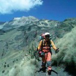
- Dave trekking down from the summit climb on Izta
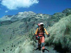
-

- Popocatepetl from Izta
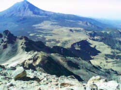
-

- Dave at Amecameca for the permits

-

- A new friend Amador at Malinche’s base
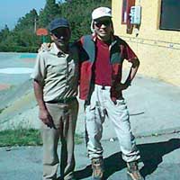
-
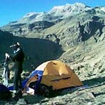
- Our camp at La Hoya, with Izta in the background
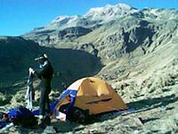
-
- David and TingSern at the expedition kick-off with the SPD flag
-
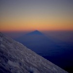
- the shadow of El Pico de Orizaba, from the near the summit
-
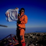
- At the summit of Orizaba. The Society for the Physically Disabled’s flag flying high!
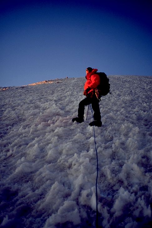
-
- Luis Ezpinosa high on Orizaba’s Espinosa Route
Solo on Iztaccihuatl (Received on 4 Mar 2003 09:13)
March 2
I set off at 5am from camp at 4,200m to push for the top of Izta (5,220m). Ting Sern stayed at the camp, keeping the fort safe! I reached the subsidiary summit of Las Rodillas (The Knees), 5,000m in 4.5 hours, before turning back; 2 hours from Izta’s highest point, El Pecho (The Breasts), I had to turn back because we have to get off the mountain in time to meet our transport. The Knees include sustained sections of 3rd class scambling and the hardest technical part of the summit climb. It was a good climb.
The transport, confirmed days before was arriving at the base of Izta, was waiting at 3pm to bring us back to Puebla. Had we reached the mountain hut at 4,500m yesterday, summitting Izta would have been assured. We are now off to Tlachichuca for Orizaba, the expedition’s main goal.
Dave
_____________________________________
Tired on Izta, Sun, 2 Mar 2003 08:10
An eventful day which started at 7am when we hauled our stuff with a view to get to the 4,500m mountain hut. I packed a tent, rope, the satcom kit with my own stuff and shuffled off.
The route traverses scree slopes and Ting Sern dropped farther behind. There are long sustained bits of loose stuff – energy sapping.
At 4,250m, I had news from other climbers coming up that Ting Sern had turned back. There is litle snow and climbing at the high altitude is the only issue we face on Izta. I dropped to 4,150m and began helping Ting Sern ditch gear. But Ting Sern’s pack was still not light enough for him, so I took on an extra 4 kg of water off him. We climbed up agaiin but at 4,300m he signalled that he was turning back. The rough terrain and his stability issues had exhausted him. I am no sherpa, and already carrying the bulk of the common gear, we pitched tent on a small saddle at 4,150. Ting Sern had tried his best but the challenges of the terrain was eventually too much for him, especially with the large pack he carried. Our friendship is more important than a rocky summit, so we descended together. Ting Sern thinks his limits were reached today….
It was a frustrating and tiring day. The end of it did not put us in position for a summit push tomorrow nor allowed for enhanced acclimatisation . Worse, the issue of Ting Sern’s capability in carrying gear and coping with the terrain is subject to discussion. Options include getting a guide for Ting Sern on Orizaba or finding ways he can climb without such loads. And I don’t have enough strength for both of us… hence the irony of ‘lightweight’ trips, it’s hard work, hauling all the gear on our own…
As for tomorrow, TS will continue acclimatising (drinking tea next to the tent) while i might go light and upwards and see how it goes – maybe gettiing to 5000m on Izta before a sprint down to the campsite. But right now we need to eat, drink and discuss our plans.
Dave
________________________________________
Buenos dias/tardes! Fri, 28 Feb 2003 12:36
What do you get when you put 2 jet-lagged, post-flu guys on a stiff hike of 3,000 vertical feet?
A : 2 sleepy and tired hombres…
We’ve just finished some acclimatisation in the La Malinche area; climbing at a rate of about 200-250 vertical metres per hour. No summit since that would have been a bit much considering we had touched down in Mexico barely 24 hours before. But we got up to around 4,200m which puts us in good stead for the big climbs ahead. We’ve made a few new friends and will be heading to Iztaccihuatl next. So far, so good.
Mexico is lively and the ‘mole poblano’ (a traditional Puebla dish) excellent.
Dave
_____________________________________
Mexico! Thu, 27 Feb 2003 1:44:36 (Singapore)
Writing from an internet cafe in Puebla (pop. 2million). Aching from the long flight… and lack of movement.
We touched down early this morning and caught a bus to Puebla, our jumping-off point for La Malinche, saw Popo (the volcano is smoking quite a bit) and Izataccihuatl en route.
We’ll be acclimatising in La Malinche tonight and going for the 4460m summit tomorrow as part of our build-up
Cheerio,
Dave and TS
_____________________________________
Feb 18th 2003: David and Ting Sern hold a media conference on the Mountain of the Star Expedition 2003. Over the past 2 weeks, David has been speaking to and encouraging thousands of students in their goal to raise S$60,000 for the Society for the Physically Disabled. All funds raised go to the SPD.
Watch this space for pictures and dispatches from Feb 25th when the team departs for Mexico.
Picture below: Dave ( L ) and Ting Sern ( R) hold the SPD flag which will go up with them to the mountains

David and TingSern at the expedition kick-off with the SPD flag
EXPEDITION PICTURE
 Cho Oyu Expedition 1997
David makes the hard push from Camp 2 (7000m) to Camp 3 (7400m). He led Singapore’s first successful attempt to an 8000m peak and summitted with four others in autumn 1997.
From this point every camp between the summit camp (3) and basecamp can be seen down the northwest ridge.

Ascents of Virgin Peaks in the Tien Shan Mountains, Kazakhstan
Jul 20 – Aug 4, 2005
Supported by:
 |
 |
 |
 |
 |
| South Col Adventures Diplomatic Mission of the Republic of Kazakhstan | ||||
Photos:
 David and Wilfred on the summit cornice of Singapura I Peak, 4589m, AD- David and Wilfred on the summit cornice of Singapura I Peak, 4589m, AD- |
 L to R: Rozani, David + Shani L to R: Rozani, David + ShaniTemasek Peak, 4374m, PD ( first summit) |
 Rozani on the steep bit, Singapura I Peak Rozani on the steep bit, Singapura I Peak |
 David on Ong Teng Cheong Peak( 4743m, PD ). Photo: Wilfred Tok David on Ong Teng Cheong Peak( 4743m, PD ). Photo: Wilfred Tok |
 Climbing Routes on the Peaks Climbing Routes on the Peaks |
 Above, L to R: Mr D. Lim, Mr George Yeo, Mr W. Tok, Mr M. Rozani (not in picture – Dr. Shani Tan). The team at the Ministry of Foreign Affairs, briefing Mr Yeo, the Expedition Patron on the expedition’s progress Above, L to R: Mr D. Lim, Mr George Yeo, Mr W. Tok, Mr M. Rozani (not in picture – Dr. Shani Tan). The team at the Ministry of Foreign Affairs, briefing Mr Yeo, the Expedition Patron on the expedition’s progress |
“I hope this interesting and unconventional endeavour will inspire other Singaporeans to follow their hearts and blaze new trails. We need a greater spirit of adventure and discovery in our society,”
Mr George Yeo, Expedition Patron, Minister of Foreign Affairs, Republic of Singapore and Expedition Patron
“On behalf of my country, I wish the expedition success. I also would like to welcome all Singapore adventurers to follow the trail set by these intrepid mountaineers in their quest to climb some of our many beautiful mountains.”
Mr. Adil Tursunov, Head of the Kazakh Diplomatic Mission in Singapore
“This is a bold and extremely challenging attempt, even for expert mountaineers. The adventurous spirit of challenging the unknown epitomises the philosophy of Food Empire, and we share in the mountaineers’ excitement of exploring exotic and ‘untamed’ peaks/markets where few dare venture.”
Mr. Tan Wang Cheow, Chairman and Managing Director of Food Empire,
“Together with Food Empire, we are delighted to support David and his team and hope that many others will emulate his passion and spirit to achieve their dreams! We believe that our firms venturing abroad can be likened to scaling new heights and charting into unknown territories. They need vision, guts and determination. They also need to study the terrain and climatic parameters, build up their own fitness before attempting the adventure. We are proud to be a part of this adventure!”
Mr. Lee Yi Shyan, CEO of IE Singapore
DESPATCHES:
23 Jul 2005, 0600hrs Basecamp
We are in Basecamp now. Flew in by helicopter yesterday which was spectacular. Weather was good until we reach basecamp. It became very foggy soon after. Basecamp is at 3850m and some of us have a bit of altitude sickness. Probably due to the rapid ascent to this attitude. We should acclimatise in a day or two, for now, lots of liquids and asprins. Otherwise, all are fine. Today’s itinery includes breakfast, acclimatising and going for recce hikes to see what potential peaks we can climb.
Dave
24 Jul 2005, 1700hrs Basecamp Siemionova Glacier
Pop the champagne!!
The team climbed our first peak today! Weather was ‘iffy’ the last 2 days. Tien Shan’s weather is warm at night and that causes soft snow which makes it harder to walk on. Today’s weather was perfect, all team members summitted a 4,374m peak, which is not even on the map. It is part of a snowy ridge next to the glacier. We have yet to figure out what to call this peak, but for now we need hot teas, soup and some eats.
Everyone’s in good health but tired after today’s achivement. We are planning to rest tomorrow. We might do a recce for another peak which we might attempt the day after, weather permitting
Dave
25 Jul 2005, 1710hrs Basecamp Siemionova Glacier
Today was a good day of rest. We did some recce. We hope that the weather will hold up. The plan for tomorrow is an early start, at dawn. We will attempt a 4,500m peak. A beautiful mountain. This is definitely a virgin peak. Everyone is feeling good. Breathing fresh air and getting hungry. : )
Dave
26 Jul 2005, 1940hrs Basecamp Siemionova Glacier
Today, Roz, Beng Cheong and I summited another virgin peak. Our altimeter reads 4,589m at the summit. We began at 2:30 am in the dark of the night. The first few hours were very cold and dark. Even with our recce and planning yesterday, this was charting new ground. The new ice crunch beneath our boots. As we suck the cold air, we kept moving one step at a time. Out headlights kept us focused on the ice and rock, and kept the dark away. Shani opted out of this climb today because it had some steep sections she was not comfortable with. It was tough going, the climb and the uncertainty of the untrodden terrain kept our adrenaline pumping. The dawn opens to a murky morning. It was then that we could see the path that we had took, a challenging route. The summit was in sight. The sun appeared much later, giving us a bit of blue skies and bright light. the last bit before the summit was a bit steep but manageable. The views at the heavily corniced summit is as always, wonderful. Didnt go to the very lip in case it might snap off! It started to snow later in the day on the last leg of our return to basecamp. We reached basecamp at about 3:30pm. It was an exhausting day. We are tired but elated that we have submitted another virgin peak.
Satellite communications from the glacier is not too stable, perhaps because we are surrounded by high mountains. We had problems calling out.
Upon returning to basecamp, we have been melting snow and making loads of tea. We are all feeling good, tired and thirsty but other than that OK. Dinner is heating up and soon we will be celebrating with some noodles and jerky (which does taste nice when you soak them in the soup)… For now, food.
: ) Dave
27 Jul 2005, 1935hrs Basecamp Siemionova Glacier
It is good to rest after yesterday’s 20 hour day. We climbed up PEAK 2 through gullies and deep snow. Often, we did not know whether the snow underneath hides the big crevice that could mean a plunge into a deep and dark place… The final ascent to the peak was spectacular, at parts, it was a 55 deg steep slope. Almost at the top, we had to crawl up a 10m overhang. It was excruciating but also very challenging. PEAK 2 did not give up her pride easily. Shani decided not to climb yesterday, taking a bit more rest after our first peak.
It will be an early night for us. We will be waking up at 2:30am again and will attempt our 3rd virgin peak. This mountain is about 4,600 – 4,700m. The peak is capped with snow and ice. Two potential routes are possible. One is a long hike up ice and glaciers, and the second is via rock gullies and scrambling across some boulders. We will take the gully route.
It is raining and snowing right now. I cooked an egg honey omelette for the team. Got to do the necessary to keep spirits up!! We didn’t carry eggs here, just the dry powder stuff that changes into mushy orange stuff when you add water to it. Tastes almost like egg…
: ) Dave
28 Jul 2005 2130 hrs Basecamp, somewhere on Siemionova Glacier
At 2:30AM the four of us attempted the 3rd peak but turned back after about 2 hours. There are 2 ways up this mountain, the fast but more risky or the longer and seemingly safer route. We tried the faster way today but came to an area with lots of loose rocks. The loose scree and ice made this very difficult for all of us, for me, it is even more of a challenge. I cannot imaging wobbling and scrambling up the mountain on this terrain. The risk is a fall down the side of the mountain, definitely not fun. We agreed that it’s way too dangerous and decided to turn back.
We will be trying the same mountain again tomorrow, this time using a the longer route. I estimate that it will take us at least 14 hrs to climb and return safely. We will begin at about 2AM again. Waking up at dawn to climb is a norm for climbing mountains. The mountains here are amazing beautiful. Even in murky weather, the mountains still peek at us. As if they are saying, come climb… higher ground. New paths… In sunny weather and at dusk, the colors are amazing. And camping on a glacier, it is never quiet. The soft creaks of the glacier is always present.
We are also trying to get off the glacier a day earlier. We have confirmed our heli rides out on the 1st.
By the way, we are cooking rice and tuna tonight. At this altitude, it does take a long time for rice to cook. At the moment we are all sitting around staring at the rice cooking. It does seem to take a long time…
: ) dave
29 Jul 2005 2110 hrs Basecamp, Summited PEAK 3 !!
We made it up Peak 3 today. This is perhaps the highest mountain in this area. It is not named and there are no height markers of this peak. It took the four of us, 8 hours of serious climbing to reach the summit of over 4,700 m. We began at 2:30AM again. The path was lit only by our headlamps and the few stars above us. The route up was a long climb with many interesting slopes. As we approach the summit, we climbed over a small crest… thinking that we had reached the summit. Only to realise that there was a even higher hump further away. This is what we face on an unclimbed mountain. We do not even have knowledge of what lies ahead and we just had to make do as we climb. The summit is an overhanging cornice. The highest spot is on an icy edge that falls off down the side of the mountain, We stood a few meters away from the edge. Not a good idea for us to fall off the mountain if the snow and ice decides to move. The climb back was equally challenging. Even then, we managed to catch some sights. The mountains surrounds us, the icy glacier below looking much like a quiet river.
We are all back safely and will be tucking in some dinner soon. It will be a rest day tomorrow and maybe we will start thinking for some names… for the peaks. Peaks 2 and 3 have been very tiring and many stretches during the climb were very exposed. All these puts a lot of physical and mental stress on us. We are utterly tired after today’s climb but the feeling is good. We have arranged for our helicopter pickup and am waiting for confirmation for our move down to a lower base but this is some days yet. For now it’s rest and food.
: ) dave
30 Jul 2005, 1735 hrs Basecamp
We slept for almost 12 hours after yesterday’s climb. I think it was something Beng Cheong did to our dinner… hrumph!! Our plans for today depends on whether we will be flying out tomorrow. We are waiting for a message via sat-coms sms to confirm flight. If there is no flight due to some reason or other, then Beng Cheong and Roz will likely go climb a mountain. From basecamp, Shani and me will try and take some shots of them climbing. If the helicopter comes tomorrow, then we will be going out. We had spent some time today on deciding on the names of the peaks…
Looking back, the last 8 days has been challenging. We virtually did 3 marathons over 8 days, lost a bit of weight, ate loads of mushy stuff, drank tea and shared many bad jokes. Not bad eh… : )
for now, Dave
31 Jul 2005, 1335 hrs Karkara
We took off on the helicopter at 10AM. The heli came in a bit early, we had a fit and a bit of a rush stuffing our gear into bags before trooping into the heli. The flight to Karkara was great, we had a good look at the mountains that we spent the last few days climbing. The sun was up and the views were great.
Civilisation… the first thing I did was to have two baths. The water runneth over rather murky. It was 8 days of grime and sweat. We just had some eats, hot teas and more eats. Everyone is happy. An interesting thing we heard, horse sausage is in season now. We will go check this out at the market tomorrow. Hope no one is pulling our leg.. Thanks for tuning in : ) Dave
The Team:
David Lim, team leader: Singapore’s most prolific mountaineer, with over 50 alpine ascents and expeditions including leading the 1st Singapore Everest Expedition in 1998, and the second (from the north ridge, 2001) Singapore Everest expedition. Partially disabled from Guillain Barre Syndrome since 1998, he continues to inspire thousands through his seminars and presentations. Made the first all-Singapore ascent of Aconcagua, the highest peak in North and South America in Feb 2000.
Mohd Rozani, climbing instructor
A member of the 1st Singapore Everest Expedition in 1998. Summitted Cho Oyu ( 8201m ) in 1997. He set an oxygen-free record when he climbed to 7950m on Everest’s North Ridge in 2001. In 2004, he led an alpine skills development team to the Paldor Peak region in Nepal
Wilfred Tok, mountaineering instructor and corporate trainer
Arguably Singapore’s most skilled technical alpinist, he has made difficult ascents in the Alps including the Gervasutti Pillar on Mt Blanc du Tacul, and climbed Aconcagua (6962m, Argentina) with David Lim. Member 2001 Singapore-Latin American Expedition
Dr Shani Tan, anaesthetist
The team’s only lady member, Dr Tan has a long climbing resume which includes summits of Aconcagua, Elbrus and Mont Blanc. She made the first Singaporean female attempt to climb Mt McKinley in Alaska in 2002. She was the official basecamp doctor for the 1st Singapore Everest Expedition in 1998.

Semionova Glacier
Stretching across large tracts of China (Xinjiang), Kazakhstan and Kyrgyzstan, the Tien Shan range contains one of the highest concentrations of unclimbed peaks in the world.
Climbing virgin peaks embodies the boldest and most imaginative of mountaineering spirit, for it takes the climber into a realm of uncertainty, risk and unknown dangers.
While the slopes of famous peaks like Mount Everest may have 40 – 50 people actually queuing up for the summit on some days; and where the trail is staked with marker flags and thousands of metres of rope, climbing virgin peaks exacts different demands on climbers. The team will be attempting peaks in th area marked in red.
 Food Empire Holdings, a Singapore-listed company, and their flagship MacCoffee range of fine instant beverages is powering the MacCoffee Tien Shan Expedition 2005
Singapore mainboard-listed Food Empire Holdings Limited (“Food Empire”) is a leading food and beverage company that manufactures and markets a wide variety of regular and flavoured coffee mixes and cappuccinos, instant chocolate, instant breakfast cereal and flavoured fruit teas. Food Empire also markets a refreshing range of confectionery, snack food and an assortment of frozen convenience food that includes Asian delicacies. Food Empire’s’ products are exported to over 50 countries globally in markets such as Russia, Eastern Europe, Central Asia, the Middle East and Indochina..Food Empire has been ranked among the top three most popular instant 3-in-1 coffee brands in the Group’s core markets.
Below: Map of Central Asia and the location of the Tien Shan mountains (circled), bordering Kazakhstan, Kyrgyzstan and Chinese Xinjiang

 In Aug 2011, David Lim will be returning to the 5895m high Mount Kilimanjaro to climb it from the Rongai Route (from the north) . This is a far different climb than the Voltaren Kilimanjaro Challenge in 2004. The 2011 team comprises David’s wife, Maureen Da Costa, long-time expedition doctor and David’s partner on the Extreme Desert Crossing Expedition in 2007 – Dr Shani Tan, and her trek companion, Juliana Kok.
  Visit the updates page on Facebook where George Tan will be updating our progress. Expect sketchy reports this time, folks! There may be occasional updates here The Rongai route is far less travelled than the popular Machame and Marangu routes from the south west and south east. The route the team will be taking will approach Kibo from the north west; crossing the scenic saddle between Mawenzi ( a satellite peak of Kilimanjaro) and then ascending the final summit route on the Marangu route (see right)
 Left: Maureen at some stair climbing training on Bukit Timah, 164m. The workout usually involves an hour or two of stari climbing the well -known long staircases of the Rengas, Summit and Jungle Fall path staircases. Alternatively, the Dairy Farm loop is also provided a decent long walk with ups and downs. Our training in Singapore, which is ‘mountain-less’ comprises running, weights, Pilates, and hillw alking. Kilimanjaro is not a technical peak. But it is high, and apart from acclimatisation, a solid aerobic fitness foundation is required to complete the climb successfully. Shani and Juliana who emigrated to New Zealand a couple of years ago have a larger variety of outdoor opportunities – although with our busy work and corporate commitments – training gets tougher the older you get!

ELBRUS DISPATCHES ( Jul 3 – 19 )
11 Jul 2003, 6:58pm Singapore time.
Just returned from acclimatisation. We climbed to just below 4,700m near Pashtukov Rocks before returning. All of us, Grant, our Russian guide, Rudolf, and me, felt great about today’s efforts. The weather looks good. We will make an attempt tonight for the summit, a day earlier than planned. We will begin our ascent at 2am… It would take at least 6 hours to summit. For now, its rest, tea, a bit of that black bread and some soup… Dave
11 Jul 2003, 10am Singapore time
We have reached 4,200m. Living on a patch of ice for the next 2 nights before we make a summit attempt. Hope to make it to the top by 13Jul. We have been having pretty nasty weather over the last 3 days…. Dave
9 Jul 2003, 7:58pm Singapore time
Just found an internet terminal ( 2 months old ) near my hotel. Primitive and slow but it works.
It’s been raining for 2 days and we have been having some cold and wet acclimatisation. We just spent 2 nights at about 3000m up the Jankom glacier near the Adyl-Su peaks; about 15km from where I am based in the Baksan valley. Some interesting snow trekking and just keeping dry was a challenge!
Elbruz has just had a plastering of 30 cm of snow and we are spending (maybe) a day to wait for better weather. Folks are bailing from the area although I am sure some will tough it out if they are on a tight schedule
A possible schedule for us:
Jul 10 – Rest at Baksan valley
11 Summit push to 4300m, near the Garabashi/Diesel Huts
12 Acclimatisation hike to Pashtukov rocks 4800m
13 Rest day
14 Summit day
We have the 15 and 16 as spare days.
So far, all is well although Russian security and related checks are irksome and an eyeopener to travelling in this varied and fascinating country.
Food is typically Russian – creamy salads, sour cabbage, meat ( and more meat ) and lunch today had some stewed veal on offer. Great black bread… Dave
8 Jul 2003, 3:25pm Singapore time
The skies just cleared after a day of rain and wind. It has been a nasty day… gusty winds. We did some trekking on a nearby glacier. Good fun except for the stinging winds. Will spend the night here at 2,859m. Next, we will go down to the village for a bit of rest and resupply before we make our summit attempt of Elbrus. We plan to make the attempt on 9Jul (Elbrus time), the push will take about 4 days in all. For now we are well and feeling good, a bit wet though… Dave
7 Jul 2003 9pm Singapore time
Woke up to a wet and grey day. We did some hiking around Adyl-su Valley. Crappy weather all round but we did managed to do some good amount of walking. Had a bit of mis-communication with our guide, he thought that we had brought food for him when we had only brought enough for two…. so now, we have to share our grub between three persons. Feeling a bit peckish!! We hope to make a summit attempt on 9/10 Jul, hopefully the weather clears up by then. For now we sleep at 2,859m…. Dave
6 Jul 4.30pm Singapore time
We have reached the Baksan Valley. Looking at Elbrus right now. It’s big! Patches of ice on its side. We will begin acclimatisation tomorrow, For now, rest and a bit of stretching after the travelling to get here. It was an eventful journey. Yin Chew lost her passport in Bangkok during our transit there. Only discovered this in Moscow. The officers here were not helpful and refused to provide a new visa for Yin Chew. She was refused entry and had to return.
The weather is good. Very hot here in the valley…. Dave
June 30: The bags are being packed and mountain food stashed for the Elbrus trip. Climbing Elbrus should be logistically easier than the Mexico volcanoes ( see left ) but few Russians in those areas speak English – so it should be an interesting cultural experience climbing in the Caucases. Dispatches from Russia will be more sporadic as a full SATCOMs rig will not be used, so don’t expect too much!
PHOTO ARCHIVE
 Grant Rawlinson on the summit in 80km/h winds Grant Rawlinson on the summit in 80km/h winds |
 David Lim on the summit in 80km/h winds. East summit in the background David Lim on the summit in 80km/h winds. East summit in the background |
 Team Elbrus after the summit. L to R: Rudolf Rother, David Lim, Grant Rawlinson. The main summit is the cone on the left. Team Elbrus after the summit. L to R: Rudolf Rother, David Lim, Grant Rawlinson. The main summit is the cone on the left. |
 Dave slogging up the final steep slopes to the summit plateau. the traverse to the west ( main ) summit is below in shadow Dave slogging up the final steep slopes to the summit plateau. the traverse to the west ( main ) summit is below in shadow |
 Traverse from the base of the East summit cone to the main summit cone. Main summit area is in the sunlight Traverse from the base of the East summit cone to the main summit cone. Main summit area is in the sunlight |
 Shadow of the main summit, 630am, summit day on Elbrus Shadow of the main summit, 630am, summit day on Elbrus |
 David at the campsite at the Adyl -Su glaciers. 3000m . Jul 8. David at the campsite at the Adyl -Su glaciers. 3000m . Jul 8. |

ELBRUS DISPATCHES (Jul 3 – 19 )
SEE PHOTO ARCHIVE ON THE ARCHIVES PAGES! FROM THE ACCLIMATISATION TO SUMMIT DAY.
14Jul 2003
Summit Day (12Jul) :
Rudolf Rother, Grant Rawlinson and myself got up at 2.30am and made our way up the icy slopes to the Pashthukov Rocks (as did about 20 other people in various groups). The average angle of the slopes were between 35 – 45 degrees. It got windy almost immediately once we were above the Rocks (4,700m) and lasted throughout the traverse around the base of Elbruz East (5,621m). The yellow moon sulkily slunk off a dull red at about 5am and it took a while for the sun to get up’ casting a huge shadow of Elbrus on the Caucasian plains below.
We rested a bit before the final steep 200m ascent up to the summit plateau. This was the toughest part of all. To be frank, we should have acclimatised for another day at our 4,300m camp. But the very changeable weather demanded a swift move. The summit was windy – 80km/h at least and people barely able to stand. Summitted at just before 9am and returned at about 1pm.
Seems we made the right move since all night on the 12th, we were buffetted by gale force winds and about 6 inches of windblown snow. The foul weather chased us all the way back down on the 13th
We’re now enjoying shashliks and beers in the valley. We have heaps of time left and will do some exploratory treks in the Elbrus are before we fly back to Moscow and then Singapore on the 18th; arriving on the 19th
Cheers
David and the South Col Adventures team
12 Jul 2003, 515pm Singapore time
We reached the summit of Elbrus, 5,642m just before 9am. Started the climb at 2am. The winds were strong and a bit nippy… much of the route up was snow covered, crusty with a bit of crunch!! (stomach talking). We are all OK, feeling great about the climb but very tired. Looking up the mountain, we see clouds coming in. Looks like more wind and snow over the next few days. Good thing we made the summit attempt today. We are down, back at camp… resting, drinking and resting…Dave
 LEFT: Elbrus from space (NASA photo) showing the summit (the west peak at 5642m) and the slightly lower east summit.
 LEFT: The normal route up Mt Elbrus follows the Baksan valley route up to the old cable cars.
A trail beyond that snakes up to various alpine shelters or huts in the 3600 – 4000m range.
Beyond this, the South Col Adventures team will place a high camp above the Pashtukhov rocks at about 4800m before making an attempt on the summit.
The ascent will be preceded by acclimatisation treks. Elbrus is a straightforward glacier climb with slopes not usually exceeding 45 degrees.
Altitude and strong winds are the main challenges.
BRIEF HISTORY OF MT. ELBRUS:
Mt Elbrus is an extinct volcanic cone situated just north of the main Caucasus range. It has the twin summits, is glaciated, and the highest point in Europe, depending on whether or not you agree anything west of the Urals is Europe!.
Elbrus lies in the Russian Republic of Kabardino-Balkaria. Its east summit was first climbed by the Kabardinian Killar Khashirov in 1829, who was employed as a guide by a Russian army scientific expedition.
The west (true) summit, was ascended in 1874 by a Balkarian guide, Akhia Sottaiev, who climbed with the team of Gardner, Grove,Walker and Knubel.
THE SOUTH COL ADVENTURES’ TEAM SCHEDULE:
Days:
1 – 3 Singapore-Moscow-Minerale Vody
4 – Baksan Valley
5- 7 Acclimatisation hikes up to Cheget, the Garabashi/ Diesel Huts
8 Rest day in valley
9 – 10 Summit push to Diesel Hut and then high camp above Pashtukhov Rocks
11-12 Summit and spare day
10th ANNIVERSARY EXPEDITION PICTURE
 David Lim and Ming Nuru Sherpa; summit of Paldor Peak, Ganesh Himal, Nepal. June 1st 1993. Picture taken by Tan Tien Chye. Paldor Peak, 5928m, was David’s and Tan’s first Himalayan peak. Together with Ming Nuru, they climbed Pema Peak (5300m) and Paldor. Paldor was climbed by the Cleare-Howell Route; well into the monsoon season.